Aldenhof
Aldenhof is a quarter in Nijmegen, Gelderland. Aldenhof is situated nearby to the suburb Dukenburg, as well as near the quarter Malvert.| Tap on a place to explore it |
Photo: Havang(nl), CC0.
Places of Interest
Highlights include Hatertsebrug and Nijmegen Dukenburg railway station.

Nijmegen Dukenburg railway station
Railway station
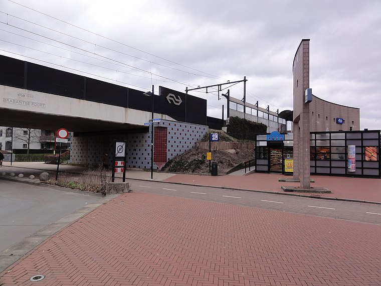
Photo: Havang(nl), CC0.
Nijmegen Dukenburg is a railway station located in the south west of Nijmegen, Netherlands. The station was opened on 2 June 1973 and is located on the Tilburg–Nijmegen railway.
Winkelcentrum Dukenburg
Shopping center

Photo: Havang(nl), CC0.
Winkelcentrum Dukenburg is a shopping center.
Places in the Area
Nearby places include Lankforst and ‘t Broek.

‘t Broek
Quarter

Photo: Orange2000, CC BY-SA 4.0.
‘t Broek is a quarter, which is situated 3 km northwest of Aldenhof.
Alverna
Village
Alverna is a village in the municipality of Wijchen in the province of Gelderland in the Netherlands. As of 2021, it had a population of 2,525. The village is named after the Alverna monastery founded there in 1887, which in turn is named after La Verna, the mountain in Tuscany where Francis of Assisi is said to have received the stigmata on 17 September 1224. Alverna is situated 3 km west of Aldenhof.
Aldenhof
- Type: Quarter
- Description: neighbourhood in Nijmegen, the Netherlands
- Categories: neighborhood and locality
- Location: Nijmegen, Gelderland, Eastern Netherlands, Netherlands, Benelux, Europe
- View on OpenStreetMap
Latitude
51.80663° or 51° 48′ 24″ northLongitude
5.7993° or 5° 47′ 58″ eastOpen location code
9F37RQ4X+MPOpenStreetMap ID
node 6605181328OpenStreetMap feature
place=quarterWikidata ID
Q2919409
This page is based on OpenStreetMap, Wikidata, and Wikimedia Commons.
We’d love your help improving our open data sources. Thank you for contributing.
Satellite Map
Discover Aldenhof from above in high-definition satellite imagery.
In Other Languages
From Dutch to French—“Aldenhof” goes by many names.
- Dutch: “Aldenhof”
- French: “Aldenhof”
Places with the Same Name
Discover other places named “Aldenhof”.
Localities in the Area
Explore places such as Dukenburg and Malvert.
Notable Places Nearby
Highlights include Lindenberg Aldenhof and Michi.
Gelderland: Must-Visit Destinations
Delve into Arnhem, Ede, Zutphen, and Doetinchem.
Curious Quarters to Discover
Uncover intriguing quarters from every corner of the globe.
About Mapcarta. Data © OpenStreetMap contributors and available under the Open Database License". Text is available under the CC BY-SA 4.0 license, except for photos, directions, and the map. Photo: Havang(nl), CC0.