Rykneld Way
Rykneld Way is a bus stop in Findern, South Derbyshire District, England. Rykneld Way is situated nearby to Micklemeadow, as well as near Haven Church.| Tap on a place to explore it |
Places of Interest Nearby
Highlights include Derby Grammar School and Littleover Community School.
Derby Grammar School
School
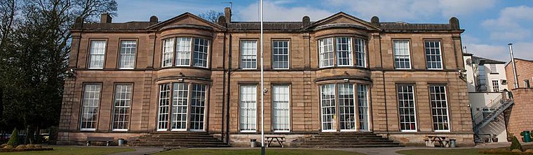
Photo: Honisoit1, CC BY-SA 3.0.
Derby Grammar School is a selective independent day school in Littleover near the city of Derby, England. Founded in 1995 as a continuation of Derby School, founded in 1160, it educates girls and boys between the ages of 4 and 18. Derby Grammar School is situated 2,800 feet northeast of Rykneld Way.
Littleover Community School
School

Photo: Victuallers, CC BY-SA 3.0.
Littleover Community School is a coeducational secondary school situated on Pastures Hill, Littleover, Derbyshire in England, with pupils aged 11–18. It is a co-educational non-denominational school which educates over 1,550 pupils from in and around Derby. Littleover Community School is situated 3,700 feet northeast of Rykneld Way.
Derby Moor Academy
School

Photo: Rpriv2000, CC BY-SA 3.0.
Derby Moor Academy, the successor school to Derby Moor Community Sports College Trust, formerly known as Derby Moor Community School, is a coeducational secondary school and sixth form situated on Moorway Lane, Littleover, Derby. Derby Moor Academy is situated 1 mile northeast of Rykneld Way.
Places in the Area
Nearby places include Heatherton Village and Mickleover.
Heatherton Village
Suburb
Heatherton Village is a residential area of Derby, England, located at the southern end of the village of Littleover, and approximately 3 miles south-west of Derby City Centre.
Mickleover
Suburb

Photo: mike smith, CC BY-SA 2.0.
Mickleover is a village in the unitary authority of Derby, in Derbyshire, England. It is 2 miles west of Derby, 10 miles northeast of Burton upon Trent, 13 miles southeast of Ashbourne and 12 miles northeast of Uttoxeter.
Findern
Village

Photo: moj palmer, CC BY-SA 2.0.
Findern is a village and civil parish in the District of South Derbyshire, approximately 5–6 miles south of Derby. The population of the civil parish was 1,669 at the 2011 Census.
Rykneld Way
- Type: Bus stop
- Category: transportation
- Location: Findern, South Derbyshire District, Derbyshire, East Midlands, England, United Kingdom, Britain and Ireland, Europe
- View on OpenStreetMap
Latitude
52.8893° or 52° 53′ 22″ northLongitude
-1.53761° or 1° 32′ 15″ westOpen location code
9C4WVFQ6+PXOpenStreetMap ID
node 6620973578OpenStreetMap feature
highway=bus_stopOpenStreetMap feature
public_transport=platform
This page is based on OpenStreetMap, Wikidata, and Wikimedia Commons.
We’d love your help improving our open data sources. Thank you for contributing.
Satellite Map
Discover Rykneld Way from above in high-definition satellite imagery.
Notable Places Nearby
Highlights include Micklemeadow and Haven Church.
Nearby Places
Explore places such as Rykneld Way and The Littleover Lodge Hotel.
Derbyshire: Must-Visit Destinations
Delve into Derby, Chesterfield, Matlock, and Buxton.
Curious Bus Stops to Discover
Uncover intriguing bus stops from every corner of the globe.
About Mapcarta. Data © OpenStreetMap contributors and available under the Open Database License". Text is available under the CC BY-SA 4.0 license, except for photos, directions, and the map. Photo: sidibousaid, CC BY 2.0.