Oficinas del Ministerio de Agricultura y Pesca, Alimentación y Medio Ambiente
Oficinas del Ministerio de Agricultura y Pesca, Alimentación y Medio Ambiente is a government office in Chamberí, Madrid, Community of Madrid which is located on Calle de Almagro. Oficinas del Ministerio de Agricultura y Pesca, Alimentación y Medio Ambiente is situated nearby to the garden Glorieta de Rubén Darío, as well as near the historic building Colegio de Ingenieros de Caminos, Canales y Puertos.| Tap on a place to explore it |
Places of Interest Nearby
Highlights include San Fermín de los Navarros and Sorolla Museum.
San Fermín de los Navarros
Church

Photo: Wikimedia, Public domain.
The Church of San Fermín de los Navarros is a church located in Madrid, Spain. It is dedicated to Saint Fermin, and replaces an earlier church dedicated to the saint which was demolished to make way for the Bank of Spain.
Sorolla Museum
Museum

Photo: Joaquín Sorolla, CC BY-SA 4.0.
The Sorolla Museum is a single-artist museum in Madrid, Spain, devoted to the work and life of Joaquín Sorolla and the members of his family, such as his daughter Elena. Sorolla Museum is situated 320 metres north of Oficinas del Ministerio de Agricultura y Pesca, Alimentación y Medio Ambiente.
Biblioteca Nacional de España
Library
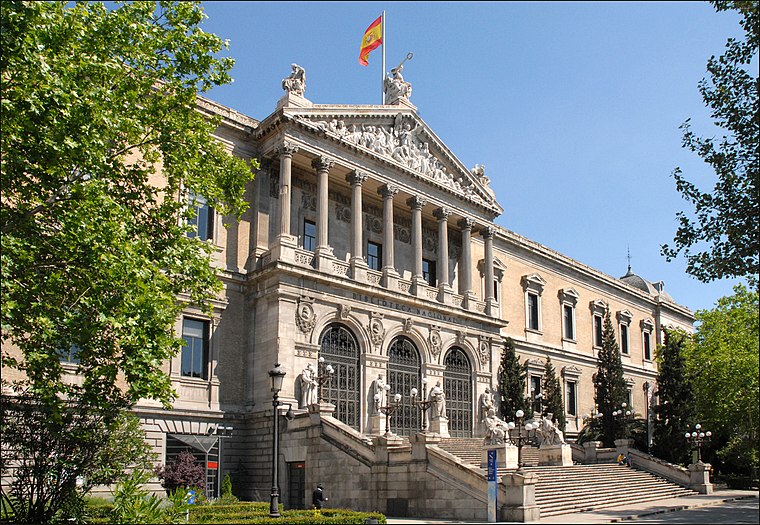 The Biblioteca Nacional de España is the national library of Spain. It is the largest public library in the country, and one of the largest in the world. Biblioteca Nacional de España is situated 1 km south of Oficinas del Ministerio de Agricultura y Pesca, Alimentación y Medio Ambiente.
Places in the Area
Nearby places include Almagro and Castellana.
Almagro
Quarter

Photo: PP Comunidad de Madrid, CC BY 2.0.
Almagro is an administrative neighborhood of Madrid belonging to the district of Chamberí.
Castellana
Quarter

Photo: PP Comunidad de Madrid, CC BY 2.0.
Castellana is a neighborhood of Madrid belonging to the district of Salamanca. It is 0.77323 km2 in size.
Trafalgar
Quarter

Photo: Wikimedia, CC BY-SA 3.0.
Trafalgar is an administrative neighborhood of Madrid belonging to the district of Chamberí. It has an area of 0.611950 km2. As of 1 February 2021, it has a population of 24,748.
Oficinas del Ministerio de Agricultura y Pesca, Alimentación y Medio Ambiente
- Type: Government office
- Address: Calle de Almagro 33, Madrid, 28010
- Categories: office and government building
- Location: Chamberí, Madrid, Madrid, Community of Madrid, Central Spain, Spain, Iberia, Europe
- View on OpenStreetMap
Latitude
40.43255° or 40° 25′ 57″ northLongitude
-3.69167° or 3° 41′ 30″ westOpen location code
8CGRC8M5+28OpenStreetMap ID
node 6723935331OpenStreetMap feature
office=government
This page is based on OpenStreetMap, Wikidata, and Wikimedia Commons.
We’d love your help improving our open data sources. Thank you for contributing.
Satellite Map
Discover Oficinas del Ministerio de Agricultura y Pesca, Alimentación y Medio Ambiente from above in high-definition satellite imagery.
Notable Places Nearby
Highlights include Glorieta de Rubén Darío and Colegio de Ingenieros de Caminos, Canales y Puertos.
Nearby Places
Explore places such as Almagro-Rubén Darío and Unicaja Banco.
Madrid: Must-Visit Destinations
Delve into Sol-Letras-Lavapiés, Salamanca, Retiro-Paseo del Arte, and Chamberí-Castellana.
Curious Government Offices to Discover
Uncover intriguing government offices from every corner of the globe.
About Mapcarta. Data © OpenStreetMap contributors and available under the Open Database License". Text is available under the CC BY-SA 4.0 license, except for photos, directions, and the map. Photo: DonPaolo, CC BY-SA 3.0.