Ma Poulette
Ma Poulette is a fast food restaurant in Saint-Leu-la-Forêt, Arrondissement of Argenteuil, Île-de-France. Ma Poulette is situated nearby to the square Place Saint Jean-Paul II, as well as near the church Chapelle Saint-Gilles.| Tap on a place to explore it |
- Opening hours:
Tuesday: 11:30 AM—11:00 PM
Thursday—Sunday: 11:30 AM—11:00 PM - Type: Fast food restaurant
- Cuisine: Portuguese
Places of Interest Nearby
Highlights include Église Saint-Leu-Saint Gilles and Saint-Leu-la-Forêt station.
Église Saint-Leu-Saint Gilles
Church

Photo: Artvill, CC BY-SA 4.0.
The Église Saint-Leu-Saint Gilles is a Roman Catholic church on the Rue Général Leclerc in the French town of Saint-Leu-la-Forêt, about 14 kilometers north of Paris.
Saint-Leu-la-Forêt station
Railway station
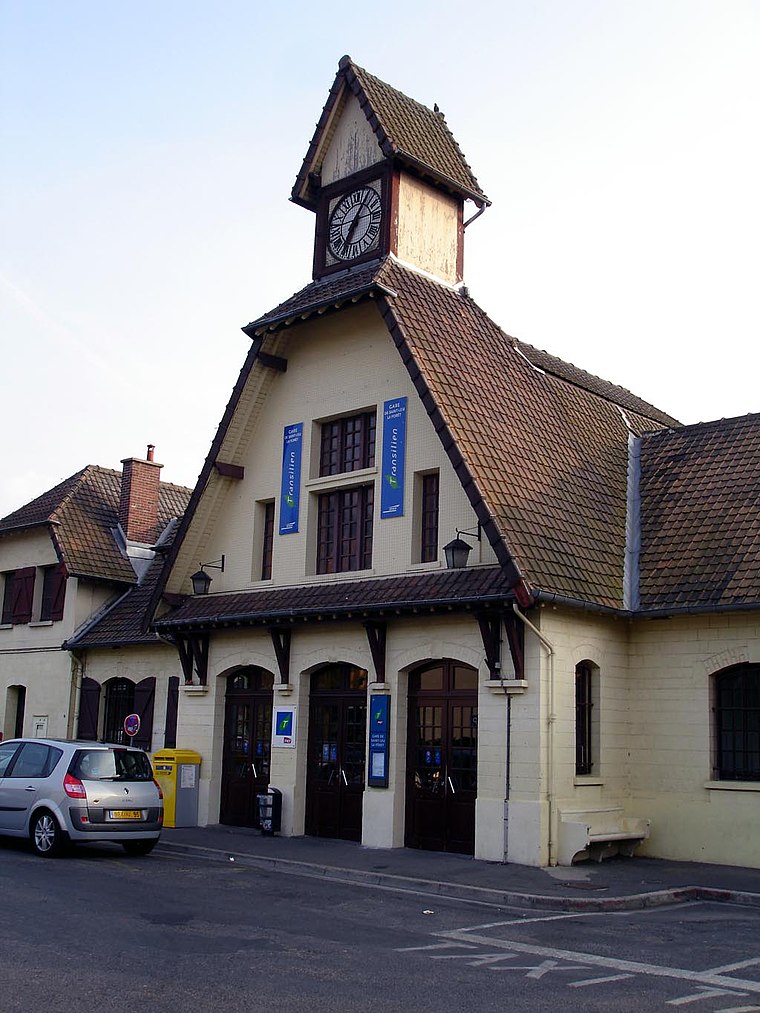
Photo: Clicsouris, CC BY-SA 2.5.
Saint-Leu-la-Forêt is a railway station located in the commune of Saint-Leu-la-Forêt, France. The station is served by Transilien H trains, on the line from Paris to Persan-Beaumont via Saint-Leu-la-Forêt. Saint-Leu-la-Forêt station is situated 360 metres southwest of Ma Poulette.
Mubarak Mosque
Mosque

Photo: Peaceworld111, CC BY-SA 4.0.
The Mubarak Mosque or Moubarak Mosque is an Ahmadi Muslim mosque located in the commune of Saint-Prix in the Val-d'Oise department in northern France. It is the first Ahmadiyya mosque in France. Mubarak Mosque is situated 1¼ km southeast of Ma Poulette.
Places in the Area
Nearby places include Taverny and Le Plessis-Bouchard.
Taverny
Town

Photo: Pymouss, CC BY-SA 4.0.
Taverny is a commune in the northwestern suburbs of Paris, France. It is located 21.2 km from the center of Paris. Inhabitants are called Tabernaciens.
Le Plessis-Bouchard
Village

Photo: Clicsouris, CC BY-SA 2.5.
Le Plessis-Bouchard is a commune in the Val-d'Oise department in Île-de-France in northern France.
Ermont
Town

Photo: Clicsouris, CC BY-SA 2.5.
Ermont is a commune in the Val-d'Oise department, in the northern suburbs of Paris, France. It is located 17.2 km from the center of Paris. It has around 28,000 inhabitants, which makes Ermont one of the most important cities in Val d'Oise. Ermont is situated 3 km south of Ma Poulette.
Ma Poulette
- Categories: food and restaurant
- Location: Saint-Leu-la-Forêt, Arrondissement of Argenteuil, Val d’Oise, Île-de-France, France, Europe
- View on OpenStreetMap
Latitude
49.01793° or 49° 1′ 5″ northLongitude
2.24567° or 2° 14′ 44″ eastOpen location code
8FX4269W+57OpenStreetMap ID
node 6897753585OpenStreetMap feature
amenity=fast_foodOpenStreetMap attribute
cuisine=portuguese
This page is based on OpenStreetMap, Wikidata, and Wikimedia Commons.
We’d love your help improving our open data sources. Thank you for contributing.
Satellite Map
Discover Ma Poulette from above in high-definition satellite imagery.
Notable Places Nearby
Highlights include Place Saint Jean-Paul II and Chapelle Saint-Gilles.
Nearby Places
Explore places such as Retoucherie elise and Ma Poulette.
Île-de-France: Must-Visit Destinations
Delve into Paris, Versailles, Boulogne-Billancourt, and Paris Charles de Gaulle Airport.
Curious Fast Food Restaurants to Discover
Uncover intriguing fast food restaurants from every corner of the globe.
About Mapcarta. Data © OpenStreetMap contributors and available under the Open Database License". Text is available under the CC BY-SA 4.0 license, except for photos, directions, and the map. Photo: Patrice78500, Public domain.