Filo El Peñón
Filo El Peñón is a peak in Santander Department, Colombia. Filo El Peñón is situated nearby to the locality Meseta San Pedro, as well as near La Ceja.| Tap on a place to explore it |
Places in the Area
Nearby places include Los Santos and Aratoca.
Los Santos
Town
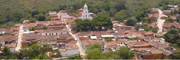
Photo: July salazar, CC BY-SA 4.0.
Los Santos is a town and municipality in the Santander Department in northeastern Colombia.
Aratoca
Town

Photo: Waltersin1960, CC BY-SA 3.0.
Aratoca is a town and municipality in the Santander Department in northcentral Colombia.
Filo El Peñón
- Type: Peak
- Category: landform
- Location: Santander Department, Colombia, South America
- View on OpenStreetMap
Latitude
6.7371° or 6° 44′ 13″ northLongitude
-73.0516° or 73° 3′ 6″ westOpen location code
67R8PWPX+R9OpenStreetMap ID
node 703524611OpenStreetMap feature
natural=peak
This page is based on OpenStreetMap, Wikidata, and Wikimedia Commons.
We’d love your help improving our open data sources. Thank you for contributing.
Satellite Map
Discover Filo El Peñón from above in high-definition satellite imagery.
Localities in the Area
Explore places such as Meseta San Pedro and La Ceja.
Notable Places Nearby
Highlights include Filo Pared De Venado and Loma La Punta.
Colombia: Must-Visit Destinations
Delve into Bogotá, Medellín, Cali, and Cartagena.
Curious Peaks to Discover
Uncover intriguing peaks from every corner of the globe.
About Mapcarta. Data © OpenStreetMap contributors and available under the Open Database License". Text is available under the CC BY-SA 4.0 license, except for photos, directions, and the map. Photo: Wikimedia, CC0.