Ellsworth-Federal
Ellsworth-Federal is a railway stop in Philadelphia, Philadelphia Region, Pennsylvania. Ellsworth-Federal is situated nearby to the church Circle of Hope, as well as near the government office PA Department of Human Services South District Office.| Tap on a place to explore it |
Places of Interest Nearby
Highlights include Ellsworth–Federal station and Independence Hall.
Ellsworth–Federal station
Metro station
Ellsworth–Federal station is a subway station on the SEPTA Metro B in South Philadelphia, Pennsylvania. The station opened on September 18, 1938, and is located at the western edge of the Italian Market on Broad Street, between Ellsworth and Federal Streets.
Independence Hall
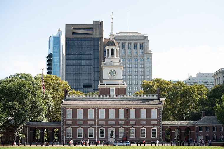
Photo: Mys 721tx, CC BY-SA 3.0.
Independence Hall is a historic civic building in Philadelphia, Pennsylvania, where both the Declaration of Independence and the Constitution of the United States were debated and adopted by the Founding Fathers of the United States. Independence Hall is situated 1¼ miles northeast of Ellsworth-Federal.
Curtis Institute of Music
University

Photo: Alsandro, CC BY-SA 3.0.
The Curtis Institute of Music is a private conservatory in Philadelphia. It offers a performance diploma, a Bachelor of Music, Master of Music in opera, and a Professional Studies Certificate in opera. Curtis Institute of Music is situated 1 mile north of Ellsworth-Federal.
Places in the Area
Nearby places include Hawthorne and Little Saigon.
Hawthorne
Neighborhood

Photo: Smallbones, Public domain.
Hawthorne is a neighborhood in the South Philadelphia section of Philadelphia, Pennsylvania, United States. It is located between Broad Street and 11th Street, and extends from South Street to Washington Avenue.
Little Saigon
Neighborhood

Photo: Minormadam, CC BY 3.0.
One of the largest Vietnamese neighborhoods in the United States is Philadelphia's Little Saigon, located in Passyunk Square, a neighborhood in South Philadelphia.
Passyunk Square
Neighborhood

Photo: Nick-philly, CC BY-SA 4.0.
Bella Vista, Italian for "beautiful sight", is a neighborhood in the South Philadelphia section of Philadelphia, Pennsylvania, United States. It is bounded by 6th Street, 11th Street, South Street and Washington Avenue. It currently has a population of 5,898.
Ellsworth-Federal
- Type: Railway stop
- Categories: transport stop and transportation
- Location: Philadelphia, Philadelphia, Philadelphia Region, Pennsylvania, Mid-Atlantic, United States, North America
- View on OpenStreetMap
Latitude
39.93679° or 39° 56′ 13″ northLongitude
-75.16695° or 75° 10′ 1″ westNetwork
SEPTAOpen location code
87F6WRPM+P6OpenStreetMap ID
node 7194216066OpenStreetMap feature
public_transport=stop_positionOpenStreetMap feature
railway=stop
This page is based on OpenStreetMap, Wikidata, and Wikimedia Commons.
We’d love your help improving our open data sources. Thank you for contributing.
Satellite Map
Discover Ellsworth-Federal from above in high-definition satellite imagery.
Places with the Same Name
Discover other places named “Ellsworth-Federal”.
Notable Places Nearby
Highlights include Circle of Hope and PA Department of Human Services South District Office.
Nearby Places
Explore places such as Solar Myth and Mui Chung.
Philadelphia: Must-Visit Destinations
Delve into Philadelphia International Airport, Old City, West Philadelphia, and Center City West.
Curious Railway Stops to Discover
Uncover intriguing railway stops from every corner of the globe.
About Mapcarta. Data © OpenStreetMap contributors and available under the Open Database License". Text is available under the CC BY-SA 4.0 license, except for photos, directions, and the map. Photo: Dave Z, CC BY 2.0.