Fulham Baptist Church
Fulham Baptist Church is a church in Hammersmith and Fulham, Greater London, England. Fulham Baptist Church is situated nearby to St Thomas of Canterbury Church, Fulham, as well as near St Thomas of Canterbury Catholic Primary School.| Tap on a place to explore it |
Places of Interest Nearby
Highlights include Stamford Bridge and Craven Cottage.
Stamford Bridge
Stadium

Photo: Arne mueseler, CC BY-SA 3.0 de.
Stamford Bridge is a football stadium in Fulham, in the Borough of Hammersmith and Fulham, in West London. It is the home of Premier League club Chelsea. Stamford Bridge is situated 3,100 feet east of Fulham Baptist Church.
Craven Cottage
Stadium
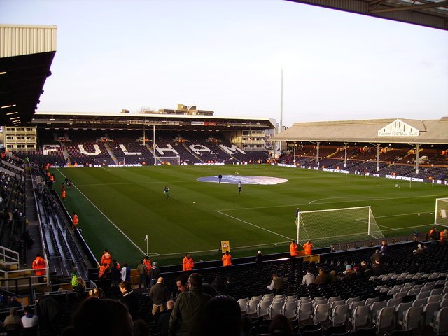
Photo: Kenneth Yarham, CC BY-SA 2.0.
Craven Cottage is a football stadium in Fulham, West London, England, which has been the home of Fulham F.C. since 1896. The ground's capacity is 29,589; the record attendance is 49,335, for a game against Millwall in 1938. Craven Cottage is situated 1 mile southwest of Fulham Baptist Church.
St Thomas of Canterbury Church, Fulham
Church

Photo: Nigel Cox, CC BY-SA 2.0.
St Thomas of Canterbury Church, also known as St Thomas's, Rylston Road, is a Roman Catholic parish church in Fulham, central London. Designed in the Gothic Revival style by Augustus Pugin in 1847, the building is Grade II* listed with Historic England. St Thomas of Canterbury Church, Fulham is situated 470 feet northwest of Fulham Baptist Church.
Places in the Area
Nearby places include Walham Green and Fulham.
Walham Green
Neighborhood
Walham Green is the historic name of an English village, now part of inner London, in the parish of Fulham in the County of Middlesex. It was located between the hamlet of North End to the north, and Parsons Green to the south.
Fulham
Suburb
 Fulham is an area of the London Borough of Hammersmith and Fulham in West London, England, 3.7 miles southwest of Charing Cross. It lies in a loop on the north bank of the River Thames, bordering Hammersmith, Kensington and Chelsea, with which it shares the area known as West Brompton.
Parsons Green
Neighborhood
 Parsons Green is a mainly residential district in the London Borough of Hammersmith and Fulham. The Green itself, which is roughly triangular, is bounded on two of its three sides by the New King's Road section of the King's Road, A308 road and Parsons Green Lane.
Fulham Baptist Church
- Type: Church
- Denomination: Baptist
- Categories: place of worship and religion
- Location: Hammersmith and Fulham, Greater London, London, England, United Kingdom, Britain and Ireland, Europe
- View on OpenStreetMap
Latitude
51.48072° or 51° 28′ 51″ northLongitude
-0.20466° or 0° 12′ 17″ westOpen location code
9C3XFQJW+74OpenStreetMap ID
node 721134650OpenStreetMap feature
amenity=place_of_worshipOpenStreetMap attribute
denomination=baptist
This page is based on OpenStreetMap, Wikidata, and Wikimedia Commons.
We’d love your help improving our open data sources. Thank you for contributing.
Satellite Map
Discover Fulham Baptist Church from above in high-definition satellite imagery.
Notable Places Nearby
Highlights include St Thomas of Canterbury Catholic Primary School and The Brunswick Club for Young People.
Nearby Places
Explore places such as Raval’s dry cleaner and Shorrolds Road.
London: Must-Visit Destinations
Delve into South Kensington-Chelsea, Heathrow Airport, City of London, and Westminster.
Curious Churches to Discover
Uncover intriguing churches from every corner of the globe.
About Mapcarta. Data © OpenStreetMap contributors and available under the Open Database License". Text is available under the CC BY-SA 4.0 license, except for photos, directions, and the map. Photo: Chmee2, CC BY-SA 3.0.