Laboratorios Polanco
Laboratorios Polanco is a laboratory in Mexico City, Central Mexico. Laboratorios Polanco is situated nearby to the place of worship Iglesia de Jesucristo de los Santos de los Ultimos Dias, as well as near the college Tecnologicos Dalups.| Tap on a place to explore it |
Places of Interest Nearby
Highlights include Suburbia and Centro Santa Fe.
Suburbia
Clothing store
Suburbia is a Mexican chain of department stores now part of the El Puerto de Liverpool group and founded in 1970 in Mexico City. Its main activity consists of the sale of clothing, appliances, electronics and cell phones aimed at the middle and lower economic classes. Suburbia is situated 470 metres northeast of Laboratorios Polanco.
Centro Santa Fe
Shopping center
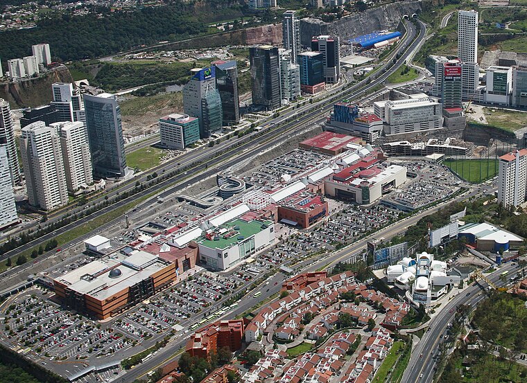 Centro Santa Fe is a large 210,400-square-metre enclosed shopping mall in the Santa Fe area in the far west side of Mexico City. Centro Santa Fe is the largest shopping center in Mexico. Centro Santa Fe is situated 2 km east of Laboratorios Polanco.
Torre Paradox

Photo: ClaraSanjurjo, CC BY-SA 4.0.
Torre Paradox is a residential skyscraper in the Chapultepec district of Mexico City, Mexico. Built between 2014 and 2018, the tower stands at 196.2 m tall with 60 floors, and is the current 15th tallest building in Mexico and the 8th tallest in Mexico City. Torre Paradox is situated 2 km east of Laboratorios Polanco.
Places in the Area
Nearby places include Santa Fe and Desert of the Lions.
Santa Fe

Photo: Serge Saint, CC BY 2.0.
Santa Fe is in the western area of Mexico City. It is the newest and most modern district of the city, as almost all of it has been developed only in the past twenty years; this puts this district in stark contrast with Mexico City's other districts, especially the Centro Historico.
Desert of the Lions

Photo: Saademoises, CC BY-SA 4.0.
Desierto de los Leones is a national park that is in the southwest section of Mexico City. It is located in the Sierra de las Cruces mountain range southwest of the city center.
Bosques de las Lomas
Neighborhood
Bosques de las Lomas is a colonia, or officially recognised neighbourhood, located in western Mexico City. It is widely considered one of the most expensive and richest areas in Latin America, and perhaps the most exclusive area in Mexico City. Bosques de las Lomas is situated 6 km northeast of Laboratorios Polanco.
Laboratorios Polanco
- Type: Laboratory
- Category: health care
- Location: Mexico City, Central Mexico, Mexico, North America
- View on OpenStreetMap
Latitude
19.36081° or 19° 21′ 39″ northLongitude
-99.29187° or 99° 17′ 31″ westOpen location code
76F29P65+87OpenStreetMap ID
node 7364479703OpenStreetMap feature
healthcare=laboratory
This page is based on OpenStreetMap, Wikidata, and Wikimedia Commons.
We’d love your help improving our open data sources. Thank you for contributing.
Satellite Map
Discover Laboratorios Polanco from above in high-definition satellite imagery.
Places with the Same Name
Discover other places named “Laboratorios Polanco”.
Notable Places Nearby
Highlights include Iglesia de Jesucristo de los Santos de los Ultimos Dias and Tecnologicos Dalups.
Nearby Places
Explore places such as meatme and Starbucks.
Mexico City: Must-Visit Destinations
Delve into Centro, Xochimilco, Condesa and Roma, and Coyoacán.
Curious Laboratories to Discover
Uncover intriguing laboratories from every corner of the globe.
About Mapcarta. Data © OpenStreetMap contributors and available under the Open Database License". Text is available under the CC BY-SA 4.0 license, except for photos, directions, and the map. Photo: Wikimedia, CC BY 2.0.