Vyhlídka pod Barabášem
Vyhlídka pod Barabášem is a scenic viewpoint in Zlín, South Moravia. Vyhlídka pod Barabášem is situated nearby to the peak Barabáš [Zlín], as well as near sjezdovka.| Tap on a place to explore it |
Places of Interest Nearby
Highlights include Trinity Bank Arena Luďka Čajky and Tomas Bata Memorial.
Trinity Bank Arena Luďka Čajky
Stadium

Photo: Pesos, CC BY-SA 3.0.
Trinity Bank Arena Luďka Čajky is an indoor sporting arena located in Zlín, Czech Republic. The capacity of the arena is 7,000 people and it was built in 1957. It is currently home to the RI Okna Berani Zlín ice hockey team. Trinity Bank Arena Luďka Čajky is situated 560 metres northwest of Vyhlídka pod Barabášem.
Tomas Bata Memorial
Museum
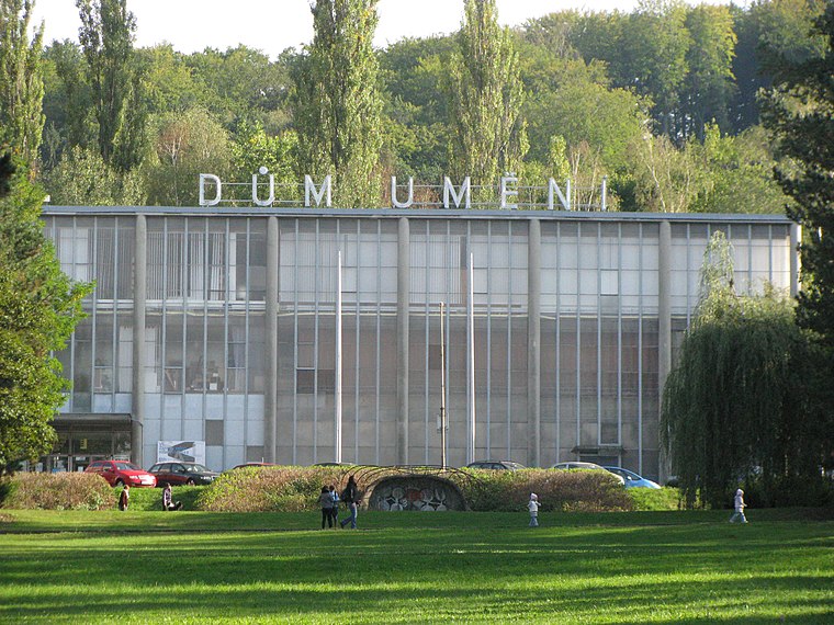
Photo: Pavellgr, CC BY-SA 3.0.
Tomas Bata Memorial is functionalist building in Zlín, Czech Republic built in 1933. The Memorial was designed by the Czech architect František Lydie Gahura. Tomas Bata Memorial is situated 550 metres north of Vyhlídka pod Barabášem.
Baťa’s Skyscraper
Public building

Photo: Romanenko, CC BY-SA 3.0.
Baťa's Skyscraper, also known as Building No. 21, is a skyscraper in Zlín, Czechia. It is 77.5 metres high and has sixteen floors. It was the administration building of Bata Shoes, a company that was based in the city. Baťa’s Skyscraper is situated 1 km northwest of Vyhlídka pod Barabášem.
Places in the Area
Nearby places include Kudlov and Prštné.


Mladcová
Suburb

Photo: Pavellgr, CC BY-SA 3.0.
Mladcová is a suburb, which is situated 3 km northwest of Vyhlídka pod Barabášem.
Vyhlídka pod Barabášem
- Type: Scenic viewpoint
- Category: tourism
- Location: Zlín, Zlín District, Zlín, South Moravia, Czech Republic, Central Europe, Europe
- View on OpenStreetMap
Latitude
49.21417° or 49° 12′ 51″ northLongitude
17.66575° or 17° 39′ 57″ eastOpen location code
8FXV6M78+M8OpenStreetMap ID
node 7374118138OpenStreetMap feature
tourism=viewpoint
This page is based on OpenStreetMap, Wikidata, and Wikimedia Commons.
We’d love your help improving our open data sources. Thank you for contributing.
Satellite Map
Discover Vyhlídka pod Barabášem from above in high-definition satellite imagery.
Notable Places Nearby
Highlights include Barabáš [Zlín] and sjezdovka.
Nearby Places
Explore places such as Hotel Tomášov and Lékárna Tomášov.
South Moravia: Must-Visit Destinations
Delve into Brno, Znojmo, Kroměříž, and Břeclav.
Curious Scenic Viewpoints to Discover
Uncover intriguing scenic viewpoints from every corner of the globe.
About Mapcarta. Data © OpenStreetMap contributors and available under the Open Database License". Text is available under the CC BY-SA 4.0 license, except for photos, directions, and the map. Photo: Wikimedia, Public domain.