Pflegedienst Puls
Pflegedienst Puls is a social service facility in Rhineland-Palatinate, Germany. Pflegedienst Puls is situated nearby to the health club WingTsun Schule, as well as near the post office Postfiliale.| Tap on a place to explore it |
- Opening hours:
Monday—Thursday: 10:00 AM—2:00 PM
Friday: 10:00 AM—noon - Email: info@pflegedienst-puls.de
- Type: Social service facility
- Wheelchair access: yes
Places of Interest Nearby
Highlights include Speyer Cathedral and Dominican sisters of Speyer.
Speyer Cathedral
Church

Photo: Gerd Eichmann, CC BY-SA 4.0.
Speyer Cathedral, officially the Imperial Cathedral Basilica of the Assumption and St Stephen, in Latin: Domus sanctae Mariae Spirae in Speyer, Germany, is the seat of the Roman Catholic Bishop of Speyer and is suffragan to the Roman Catholic Archdiocese of Bamberg. Speyer Cathedral is situated 2 km east of Pflegedienst Puls.
Dominican sisters of Speyer
Monastery

Photo: 3268zauber, CC BY-SA 3.0.
Dominican sisters of Speyer is a monastery, which is situated 580 metres south of Pflegedienst Puls.
Speyer Hauptbahnhof
Railway station
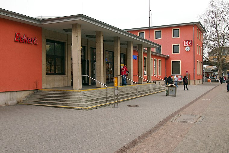
Photo: BlueBreezeWiki, CC BY-SA 3.0.
Speyer Hauptbahnhof is the more important of the two railway stations in the city of Speyer in the German state of Rhineland-Palatinate. Speyer Hauptbahnhof is situated 1 km northeast of Pflegedienst Puls.
Places in the Area
Nearby places include Speyer and Römerberg.
Speyer
 Speyer is a city in the Rhineland-Palatinate region of Germany. It is one of the oldest German cities and has a beautiful old town. Speyer has been a diocesan town since 346; its first churches and monasteries were built in the 6th and 7th century.
Römerberg
Village
Römerberg is a municipality in the Rhein-Pfalz-Kreis, in Rhineland-Palatinate, Germany. It is situated on the left bank of the Rhine, approximately 5 kilometres southwest of Speyer. Römerberg is situated 4½ km south of Pflegedienst Puls.
Hanhofen
Village

Photo: Immanuel Giel, CC0.
Hanhofen is a municipality in the Rhein-Pfalz-Kreis, in Rhineland-Palatinate, Germany. Hanhofen is situated 5 km west of Pflegedienst Puls.
Pflegedienst Puls
Latitude
49.32056° or 49° 19′ 14″ northLongitude
8.41783° or 8° 25′ 4″ eastOpen location code
8FXC8CC9+64OpenStreetMap ID
node 7396971297OpenStreetMap feature
amenity=social_facilityOpenStreetMap attribute
wheelchair=yes
This page is based on OpenStreetMap, Wikidata, and Wikimedia Commons.
We’d love your help improving our open data sources. Thank you for contributing.
Satellite Map
Discover Pflegedienst Puls from above in high-definition satellite imagery.
Notable Places Nearby
Highlights include WingTsun Schule and Postfiliale.
Nearby Places
Explore places such as Bäckerei Wilhelmi and West-Aphotheke.
Rhineland-Palatinate: Must-Visit Destinations
Delve into Mainz, Trier, Koblenz, and Worms.
Curious Social Service Facilities to Discover
Uncover intriguing social service facilities from every corner of the globe.
About Mapcarta. Data © OpenStreetMap contributors and available under the Open Database License". Text is available under the CC BY-SA 4.0 license, except for photos, directions, and the map. Photo: Traveler100, CC BY-SA 3.0.