VindingRijk
VindingRijk is a school in Apeldoorn Municipality, Gelderland which is located on Ravelijn. VindingRijk is situated nearby to the community center Het Bolwerk, as well as near the pitch Cruyff Court.| Tap on a place to explore it |
Places of Interest Nearby
Highlights include Apeldoorn Osseveld railway station and Omnisport Apeldoorn.
Apeldoorn Osseveld railway station
Railway station
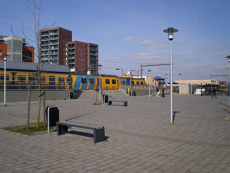
Photo: Apdency, CC BY-SA 3.0.
Apeldoorn Osseveld is a railway station located in Apeldoorn, Netherlands. The station was opened on 10 December 2006 and is located on the Apeldoorn–Deventer railway. The services is operated by Nederlandse Spoorwegen. Apeldoorn Osseveld railway station is situated 120 metres north of VindingRijk.
Omnisport Apeldoorn
Stadium
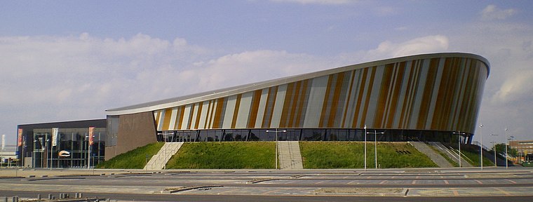
Photo: Apdency, Public domain.
The Omnisport Apeldoorn, also known as the Omnisportcentrum or simply called Omnisport, is a velodrome and multisport indoor arena in Apeldoorn, the Netherlands. Omnisport Apeldoorn is situated 1 km southwest of VindingRijk.
Danseres, Verbon
Work of art
 Danseres, Verbon is a work of art, which is situated 280 metres northwest of VindingRijk.
Places in the Area
Nearby places include Apeldoorn and Teuge.
Apeldoorn

Photo: Kleinleugenmors, CC BY-SA 3.0.
Apeldoorn is a city with a royal touch, famous for its palace and beautiful gardens. It lies on the edge of National Park the Veluwe, and is an excellent base to explore this region's lush natural surroundings.
Teuge
Village
Teuge is a village in the Dutch province of Gelderland, between Apeldoorn and Deventer. It is part of the municipality of Voorst. Its population is around 800 people and it is best known for being the location of Teuge International Airport. Teuge is situated 3½ km northeast of VindingRijk.
Wilp-Achterhoek
Village

Photo: Erik Wannee, CC BY-SA 4.0.
Wilp-Achterhoek is a village, which is situated 4½ km east of VindingRijk.
VindingRijk
- Type: School
- Address: Ravelijn 55, Apeldoorn, 7325NT
- Category: education
- Location: Apeldoorn Municipality, Gelderland, Eastern Netherlands, Netherlands, Benelux, Europe
- View on OpenStreetMap
Latitude
52.21467° or 52° 12′ 53″ northLongitude
6.00572° or 6° 0′ 21″ eastOperator
Leerplein055Open location code
9F486274+V7OpenStreetMap ID
node 7559649880OpenStreetMap feature
amenity=school
This page is based on OpenStreetMap, Wikidata, and Wikimedia Commons.
We’d love your help improving our open data sources. Thank you for contributing.
Satellite Map
Discover VindingRijk from above in high-definition satellite imagery.
Places with the Same Name
Discover other places named “VindingRijk”.
Notable Places Nearby
Highlights include Het Bolwerk and Cruyff Court.
Nearby Places
Explore places such as Talma Borgh and Herdenkingszuil Joodse geschiedenis - familie van Son.
Gelderland: Must-Visit Destinations
Delve into Arnhem, Nijmegen, Ede, and Zutphen.
Curious Places to Discover
Uncover intriguing places from every corner of the globe.
About Mapcarta. Data © OpenStreetMap contributors and available under the Open Database License". Text is available under the CC BY-SA 4.0 license, except for photos, directions, and the map. Photo: Agnes Monkelbaan, CC BY-SA 4.0.