Mukumbarí
Mukumbarí is a fast food restaurant in Central Santiago, Santiago province, Santiago Metropolitan. Mukumbarí is situated nearby to the government office Centro Abierto Manuel Rodriguez, as well as near Centro de Educación y Trabajo Metropolitano.| Tap on a place to explore it |
Places of Interest Nearby
Highlights include Emergency and Public Asistance Hospital and Santa Lucía Hill.
Emergency and Public Asistance Hospital
Hospital

Photo: Carlos yo, CC BY-SA 4.0.
Emergency and Public Asistance Hospital is situated 300 metres northeast of Mukumbarí.
Santa Lucía Hill
Peak

Photo: Rjcastillo, CC BY-SA 4.0.
Santa Lucía Hill, also known in Mapuche as Huelén Hill, is a small hill in the centre of Santiago, Chile. It is situated between Alameda del Libertador Bernardo O'Higgins in the south, Santa Lucía Street in the west and Victoria Subercaseaux on the east.
Chilean National Museum of Fine Arts
Museum
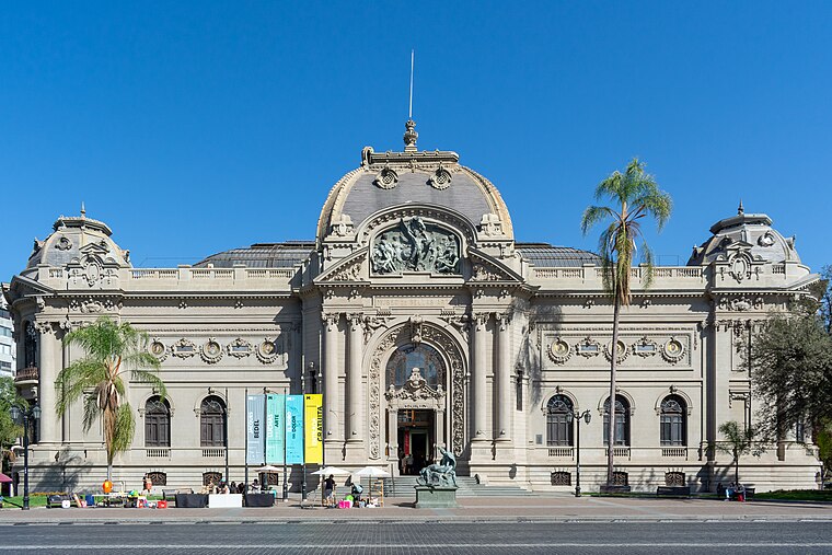
Photo: Carlos yo, CC BY-SA 4.0.
The Chilean National Museum of Fine Arts, located in Santiago, Chile, is one of the major centers for Chilean art and for broader South American art. Established in 1880, the organization is managed by the Artistic Union. Chilean National Museum of Fine Arts is situated 1¼ km north of Mukumbarí.
Places in the Area
Nearby places include Remodelación San Borja and Barrio Lastarria.
Remodelación San Borja
Neighborhood

Photo: Pedro Felipe, CC BY-SA 4.0.
Remodelación San Borja is a neighborhood.
Barrio Lastarria
Neighborhood

Photo: Marco Nuñez, CC BY 2.0.
The Historic Center is the traditional financial downtown district in Santiago. It comprises the historical center, including Cerro Santa Lucia, historic and public buildings.

Mukumbarí
- Type: Fast food restaurant
- Cuisine: sandwich
- Categories: food and restaurant
- Location: Central Santiago, Santiago province, Santiago Metropolitan, Chile, South America
- View on OpenStreetMap
Latitude
-33.44561° or 33° 26′ 44″ southLongitude
-70.64077° or 70° 38′ 27″ westOpen location code
47RFH935+QMOpenStreetMap ID
node 7660028319OpenStreetMap feature
amenity=fast_foodOpenStreetMap attribute
cuisine=sandwich
This page is based on OpenStreetMap, Wikidata, and Wikimedia Commons.
We’d love your help improving our open data sources. Thank you for contributing.
Satellite Map
Discover Mukumbarí from above in high-definition satellite imagery.
Notable Places Nearby
Highlights include Centro Abierto Manuel Rodriguez and Centro de Educación y Trabajo Metropolitano.
Nearby Places
Explore places such as ComTech and Cultura Chupistica.
Chile: Must-Visit Destinations
Delve into Central Chile, Santiago, Valparaíso, and Concepción.
Curious Fast Food Restaurants to Discover
Uncover intriguing fast food restaurants from every corner of the globe.
About Mapcarta. Data © OpenStreetMap contributors and available under the Open Database License". Text is available under the CC BY-SA 4.0 license, except for photos, directions, and the map. Photo: Wikimedia, CC0.