Römerspuren
Römerspuren is in Haltern am See, Recklinghausen, North Rhine-Westphalia. Römerspuren is situated nearby to the playground Spielplatz ‘Im Hohen Winkel’, as well as near the chapel Annakapelle.| Tap on a place to explore it |
Places of Interest Nearby
Highlights include Westfälisches Römermuseum Haltern and Haltern am See station.
Westfälisches Römermuseum Haltern
Museum
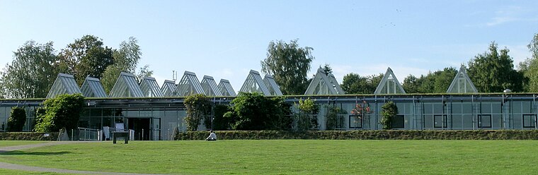
Photo: JosefLehmkuhl, Public domain.
Westfälisches Römermuseum Haltern is situated 620 metres northeast of Römerspuren.
Haltern am See station
Railway station
 Haltern am See station is a station in the town of Haltern am See in the German state of North Rhine-Westphalia on Wanne-Eickel–Hamburg railway from Wanne-Eickel to Hamburg. Haltern am See station is situated 1¼ km east of Römerspuren.
Holy Cross Church
Church

Photo: Chris06, CC BY-SA 4.0.
Holy Cross Church is situated 1½ km south of Römerspuren.
Places in the Area
Nearby places include Pilgrimage area of Annaberg (Haltern am See) and Hamm-Bossendorf.
Pilgrimage area of Annaberg (Haltern am See)
Locality

Photo: Wikimedia, CC BY-SA 4.0.
Pilgrimage area of Annaberg (Haltern am See) is a locality.

Holtwick
Village

Photo: Stahlkocher, CC BY-SA 3.0.
Holtwick is a village, which is situated 3 km northwest of Römerspuren.
Römerspuren
- Type: Sign
- Categories: information and tourism
- Location: Haltern am See, Recklinghausen, Münster, Münsterland, North Rhine-Westphalia, Germany, Central Europe, Europe
- View on OpenStreetMap
Latitude
51.73487° or 51° 44′ 6″ northLongitude
7.16589° or 7° 9′ 57″ eastOpen location code
9F39P5M8+W9OpenStreetMap ID
node 7707927917OpenStreetMap feature
tourism=information
This page is based on OpenStreetMap, Wikidata, and Wikimedia Commons.
We’d love your help improving our open data sources. Thank you for contributing.
Satellite Map
Discover Römerspuren from above in high-definition satellite imagery.
Places with the Same Name
Discover other places named “Römerspuren”.
Notable Places Nearby
Highlights include Spielplatz ‘Im Hohen Winkel’ and Annakapelle.
Nearby Places
Explore places such as Krumme Meer and Krumme Meer.
Münsterland: Must-Visit Destinations
Delve into Münster, Bocholt, Dülmen, and Rheine.
Curious Places to Discover
Uncover intriguing places from every corner of the globe.
About Mapcarta. Data © OpenStreetMap contributors and available under the Open Database License". Text is available under the CC BY-SA 4.0 license, except for photos, directions, and the map. Photo: Wikimedia, CC0.