Walt Green & Co
Walt Green & Co is a community center in Haringey, Greater London, England which is located on Myddleton Road. Walt Green & Co is situated nearby to the marketplace Myddleton Road Market, as well as near the health club Giants Gym.| Tap on a place to explore it |
- Type: Community center
- Also known as: “George Moore Menswear”
- Address: 99 Myddleton Road, London, N22 8NE
Places of Interest Nearby
Highlights include Bowes Park railway station and Bounds Green tube station.
Bowes Park railway station
Railway station

Photo: Sunil060902, CC BY-SA 3.0.
Bowes Park railway station is in the London Borough of Haringey in north London, and is on the boundary of Travelcard Zone 3 and Travelcard Zone 4. It is 5 miles 55 chains down the line from London King's Cross. Bowes Park railway station is situated 660 feet northwest of Walt Green & Co.
Bounds Green tube station
Metro station
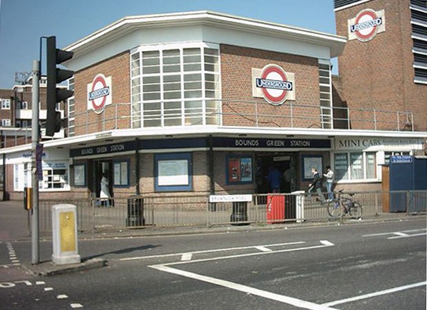
Photo: Voyager, Public domain.
Bounds Green is a London Underground station. It is located at the junction of Bounds Green Road and Brownlow Road in Bounds Green in the London Borough of Haringey, North London. Bounds Green tube station is situated 1,600 feet west of Walt Green & Co.
Ally Pally

Photo: Pianistinator, CC BY-SA 4.0.
Alexandra Palace is an entertainment and sports venue in North London, situated between Wood Green and Muswell Hill in the London Borough of Haringey. A Grade II listed building, it is built on the site of Tottenham Wood and the later Tottenham Wood Farm. Ally Pally is situated 1 mile southwest of Walt Green & Co.
Places in the Area
Nearby places include Bowes Park and Wood Green.
Bowes Park
Quarter
Photo: Mcsony, CC BY-SA 3.0.
Bowes Park is situated on the borders of Wood Green, Palmers Green and Bounds Green in London, England. The postcodes for Bowes Park are N11, N13 and N22.
Wood Green
Town

Photo: Vicky Ayech, CC BY-SA 2.0.
Wood Green is a suburban district of the London Borough of Haringey, London, England. Its postal district is N22, with parts in N8 or N15. The London Plan identifies it as one of the metropolitan centres in Greater London, and today it forms a major commercial district of north London.
Palmers Green
Suburb

Photo: John Salmon, CC BY-SA 2.0.
Palmers Green is a suburban area and electoral ward in north London, England, within the London Borough of Enfield. It is located within the N13 postcode district, around 8 miles north of Charing Cross.
Walt Green & Co
Latitude
51.60635° or 51° 36′ 23″ northLongitude
-0.11788° or 0° 7′ 4″ westOpen location code
9C3XJV4J+GROpenStreetMap ID
node 7798793804OpenStreetMap feature
amenity=community_centre
This page is based on OpenStreetMap, Wikidata, and Wikimedia Commons.
We’d love your help improving our open data sources. Thank you for contributing.
Satellite Map
Discover Walt Green & Co from above in high-definition satellite imagery.
Notable Places Nearby
Highlights include Myddleton Road Market and Giants Gym.
Nearby Places
Explore places such as ca estates and The Step.
England: Must-Visit Destinations
Delve into London, Manchester, Sheffield, and Leeds.
Curious Community Centers to Discover
Uncover intriguing community centers from every corner of the globe.
About Mapcarta. Data © OpenStreetMap contributors and available under the Open Database License". Text is available under the CC BY-SA 4.0 license, except for photos, directions, and the map. Photo: sidibousaid, CC BY 2.0.