Café La Barrière
Café La Barrière is a pub in Oupeye, Liège, Wallonia. Café La Barrière is situated nearby to the library Bibliotheque communale, as well as near the public building Ancienne maison communale.| Tap on a place to explore it |
Places of Interest Nearby
Highlights include Castle of Oupeye and Fort de Pontisse.
Castle of Oupeye
Community center
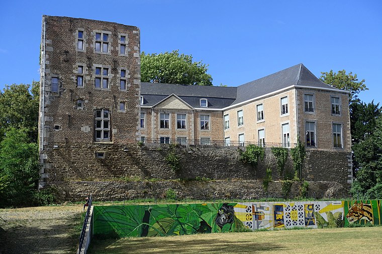
Photo: Eebie, CC BY-SA 4.0.
Castle of Oupeye is a community center, which is situated 470 metres east of Café La Barrière.
Fort de Pontisse
Fort
The Fort de Pontisse is one of twelve forts built around Liège, Belgium, in the late 19th century. The overall Fortified Position of Liège was a constituent part of the country's National Redoubt. Fort de Pontisse is situated 2 km south of Café La Barrière.
Castle of Argenteau
Castle
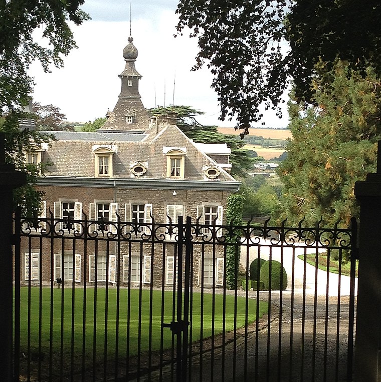
Photo: Hoebele, CC BY-SA 4.0.
Castle of Argenteau is situated 3 km east of Café La Barrière.
Places in the Area
Nearby places include Argenteau and Cheratte.
Argenteau
Village

Photo: Flamenc, CC BY-SA 3.0.
Argenteau is a village, which is situated 3 km east of Café La Barrière.
Cheratte
Village

Photo: flamenc, CC BY-SA 3.0.
Cheratte is a village, which is situated 3½ km southeast of Café La Barrière.
Richelle
Village

Photo: Flamenc, CC BY-SA 3.0.
Richelle is a village, which is situated 3½ km east of Café La Barrière.
Café La Barrière
Latitude
50.70876° or 50° 42′ 32″ northLongitude
5.64458° or 5° 38′ 41″ eastOpen location code
9F27PJ5V+GROpenStreetMap ID
node 7832774465OpenStreetMap feature
amenity=pub
This page is based on OpenStreetMap, Wikidata, and Wikimedia Commons.
We’d love your help improving our open data sources. Thank you for contributing.
Satellite Map
Discover Café La Barrière from above in high-definition satellite imagery.
Notable Places Nearby
Highlights include Bibliotheque communale and Ancienne maison communale.
Nearby Places
Explore places such as Oupeye La Barrière and ING.
Curious Pubs to Discover
Uncover intriguing pubs from every corner of the globe.
About Mapcarta. Data © OpenStreetMap contributors and available under the Open Database License". Text is available under the CC BY-SA 4.0 license, except for photos, directions, and the map. Photo: A.Savin, CC BY-SA 3.0.