Nadleśnictwo Szklarska Poręba
Nadleśnictwo Szklarska Poręba is in Kořenov, Jablonec nad Nisou District, Liberec Region. Nadleśnictwo Szklarska Poręba is situated nearby to the grassland Kobyla Łąka/Kobielowa Łąka, as well as near Ruina domu, dawny adres Kobelwiese nr 246.| Tap on a place to explore it |
Places of Interest Nearby
Highlights include Jizera Meadow and Kobyła.
Jizera Meadow
Meadow
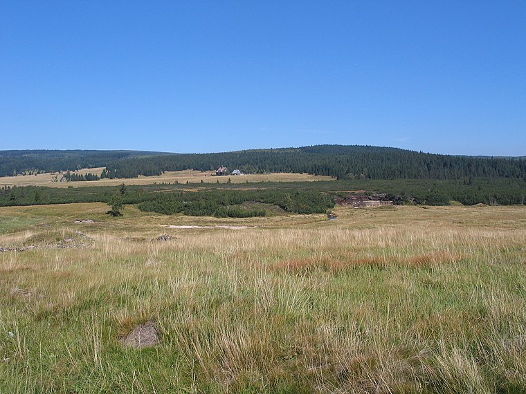
Photo: Jojo 1, CC BY-SA 3.0.
The Jizera Meadow is an alpine meadow located at an altitude of 840–880 m above sea level in the valley of the Jizera River in the Jizera Mountains in the Sudetes. Jizera Meadow is situated 1½ km northwest of Nadleśnictwo Szklarska Poręba.

Places in the Area
Nearby places include Groß Iser and Jizerka.
Groß Iser
Locality

Photo: Wikimedia, Public domain.
Groß Iser was a village on Hala Izerska existing from the 17th century until 1945. Today the remains of the village can be found in Poland just by the Czech border. The closest towns are Świeradów-Zdrój on the Polish side and Harrachov on the Czech side.
Jizerka
Hamlet

Photo: RomanM82, CC BY-SA 4.0.
Jizerka is part of municipality Kořenov in Jablonec nad Nisou District. The hamlet located in the Bohemian part of Jizera Mountains, on the border with Silesia, Poland. Jizerka is situated 2½ km southwest of Nadleśnictwo Szklarska Poręba.
Jakuszyce
Hamlet
 Jakuszyce is a hamlet, which is situated 5 km southeast of Nadleśnictwo Szklarska Poręba.
Nadleśnictwo Szklarska Poręba
- Type: Information
- Category: tourism
- Location: Kořenov, Jablonec nad Nisou District, Liberec Region, Czech Republic, Central Europe, Europe
- View on OpenStreetMap
Latitude
50.83642° or 50° 50′ 11″ northLongitude
15.36906° or 15° 22′ 9″ eastOpen location code
9F2QR9P9+HJOpenStreetMap ID
node 7851246295OpenStreetMap feature
tourism=information
This page is based on OpenStreetMap, Wikidata, and Wikimedia Commons.
We’d love your help improving our open data sources. Thank you for contributing.
Satellite Map
Discover Nadleśnictwo Szklarska Poręba from above in high-definition satellite imagery.
Notable Places Nearby
Highlights include Kobyla Łąka/Kobielowa Łąka and Ruina domu, dawny adres Kobelwiese nr 246.
Nearby Places
Explore places such as Przystanek ‘Dolina Izery’ and Historie ochrany jizerskohorský rašelnisť.
Czech Republic: Must-Visit Destinations
Delve into Prague, Brno, Pilsen, and Ostrava.
Curious Places to Discover
Uncover intriguing places from every corner of the globe.
About Mapcarta. Data © OpenStreetMap contributors and available under the Open Database License". Text is available under the CC BY-SA 4.0 license, except for photos, directions, and the map. Photo: john mcsporran, CC BY 2.0.