Teddington Council School WW1
Teddington Council School WW1 is a memorial in Richmond upon Thames, Greater London, England. Teddington Council School WW1 is situated nearby to Stanley Primary School, as well as near Swimming Pool.| Tap on a place to explore it |
Places of Interest Nearby
Highlights include Fulwell railway station and St Michael’s, Fulwell.
Fulwell railway station
Railway station

Photo: Sunil060902, CC BY-SA 3.0.
Fulwell railway station on the Shepperton Branch Line serves Fulwell in the London Borough of Richmond upon Thames. It is in Travelcard Zone 6. It is 12 miles 75 chains down the line from London Waterloo. Fulwell railway station is situated 640 feet west of Teddington Council School WW1.
St Michael’s, Fulwell
Church

Photo: John Salmon, CC BY-SA 2.0.
St Michael's Fulwell is a Grade II listed Church of England church on Wilcox Road in Fulwell, a neighbourhood of Teddington in the London Borough of Richmond upon Thames. St Michael’s, Fulwell is situated 380 feet southwest of Teddington Council School WW1.
Teddington Cemetery
Cemetery

Photo: Jim Linwood, CC BY 2.0.
Teddington Cemetery is a Grade II listed municipal cemetery in the north of Teddington in the London Borough of Richmond upon Thames. Opened in 1879 it has many tall, eclectic trees and its nucleus was the outcome of a competition for designs by Richmond Burial Board. Teddington Cemetery is situated 1,000 feet east of Teddington Council School WW1.
Places in the Area
Nearby places include Strawberry Hill and Hampton Hill.
Strawberry Hill
Suburb

Photo: Colin Smith, CC BY-SA 2.0.
Strawberry Hill is an area of the London Borough of Richmond upon Thames in Twickenham. It is a suburban development situated 10.4 miles west south-west of Charing Cross.
Hampton Hill
Suburb
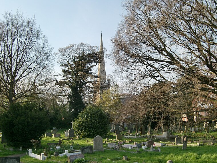
Photo: Jonathan Cardy, CC BY-SA 3.0.
Hampton Hill is a district in the London Borough of Richmond upon Thames to the south of Twickenham and around 1.5 miles north of the Surrey border. It is bounded by Fulwell and Twickenham Golf Courses to the northwest; a railway line road bridge at the…
Teddington
Town

Photo: Roger Davies, CC BY-SA 2.0.
Teddington is an affluent suburb of London in the London Borough of Richmond upon Thames. Historically an ancient parish in the county of Middlesex and situated close to the border with Surrey, the district became part of Greater London in 1965.
Teddington Council School WW1
- Type: Memorial
- Category: historic site
- Location: Richmond upon Thames, Greater London, England, United Kingdom, Britain and Ireland, Europe
- View on OpenStreetMap
Latitude
51.43397° or 51° 26′ 2″ northLongitude
-0.34624° or 0° 20′ 47″ westOpen location code
9C3XCMM3+HGOpenStreetMap ID
node 8003122375OpenStreetMap feature
historic=memorial
This page is based on OpenStreetMap, Wikidata, and Wikimedia Commons.
We’d love your help improving our open data sources. Thank you for contributing.
Satellite Map
Discover Teddington Council School WW1 from above in high-definition satellite imagery.
Notable Places Nearby
Highlights include Stanley Primary School and Swimming Pool.
Nearby Places
Explore places such as Fulwell Station and Fulwell.
England: Must-Visit Destinations
Delve into London, Manchester, Sheffield, and Leeds.
Curious Memorials to Discover
Uncover intriguing memorials from every corner of the globe.
About Mapcarta. Data © OpenStreetMap contributors and available under the Open Database License". Text is available under the CC BY-SA 4.0 license, except for photos, directions, and the map. Photo: sidibousaid, CC BY 2.0.