Lille-Flandres
Lille-Flandres is a railway stop in Lille, North, Hauts-de-France. Lille-Flandres is situated nearby to Place de la Gare, as well as near the post office Relais La Poste.| Tap on a place to explore it |
Places of Interest Nearby
Highlights include Gare de Lille Flandres and Gare de Lille Europe.
Gare de Lille Flandres
Railway station
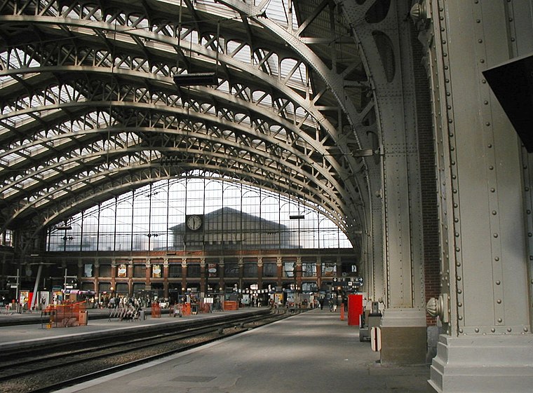
Photo: Wikimedia, Public domain.
Lille-Flandres station is the main railway station of Lille, capital of French Flanders. It is a terminus for SNCF Intercity and regional trains. It opened in 1842 as the Gare de Lille, but was renamed in 1993 when Lille Europe station opened.
Gare de Lille Europe
Railway station

Photo: JÄNNICK Jérémy, Public domain.
Lille–Europe station is a SNCF railway station in Lille, France, on the LGV Nord high-speed railway. The station is primarily used for international Eurostar and long-distance SNCF TGV services, although some high-speed regional trains also call at the station. Gare de Lille Europe is situated 460 metres northeast of Lille-Flandres.
Gare Lille-Flandres
Metro station

Photo: Floflo62, CC BY-SA 4.0.
Gare Lille-Flandres is a metro station, which is situated 120 metres north of Lille-Flandres.
Places in the Area
Nearby places include Porte de Tournai and Euralille.

Euralille
Suburb
Euralille is an urban quarter in the centre of Lille, France. Conceived as a major European business district in the late 1980s and early 1990s, it is strategically located at the intersection of the high-speed railway lines linking Paris, Brussels, and London, and incorporates the Gare de Lille Europe and Gare de Lille Flandres railway stations.
Vieux-Lille
Suburb
Vieux-Lille is a district in the north of Lille. It is the district with the most pre-19th-century buildings. It still boasts many cobbled streets and traces of the canals that crisscrossed the city in centuries gone by. It is home to 20,000 inhabitants.
Lille-Flandres
- Type: Railway stop
- Categories: transport stop and transportation
- Location: Lille, Arrondissement of Lille, North, Hauts-de-France, France, Europe
- View on OpenStreetMap
Latitude
50.63635° or 50° 38′ 11″ northLongitude
3.07077° or 3° 4′ 15″ eastOpen location code
9F25J3PC+G8OpenStreetMap ID
node 8117226490OpenStreetMap feature
public_transport=stop_positionOpenStreetMap feature
railway=stop
This page is based on OpenStreetMap, Wikidata, and Wikimedia Commons.
We’d love your help improving our open data sources. Thank you for contributing.
Satellite Map
Discover Lille-Flandres from above in high-definition satellite imagery.
Places with the Same Name
Discover other places named “Lille-Flandres”.
Notable Places Nearby
Highlights include Place de la Gare and Relais La Poste.
Nearby Places
Explore places such as Lille-Flandres and So! Coffee.
Hauts-de-France: Must-Visit Destinations
Delve into Dunkirk, Calais, Amiens, and Arras.
Curious Railway Stops to Discover
Uncover intriguing railway stops from every corner of the globe.
About Mapcarta. Data © OpenStreetMap contributors and available under the Open Database License". Text is available under the CC BY-SA 4.0 license, except for photos, directions, and the map. Photo: Velvet, CC BY-SA 3.0.