M66 Dort Fuel
M66 Dort Fuel is a convenience store in City of Flint, Genesee, Michigan which is located on North Dort Highway. M66 Dort Fuel is situated nearby to Amos Park, as well as near Delaware Park.| Tap on a place to explore it |
Places of Interest Nearby
Highlights include Flint Institute of Arts and The Whiting.
Flint Institute of Arts
Arts center
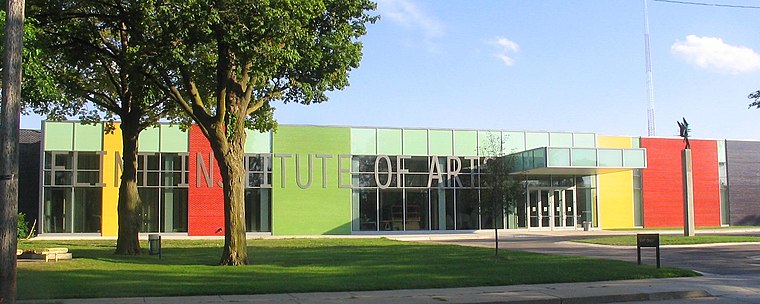
Photo: Blueskiesfalling, Public domain.
The Flint Institute of Arts, also called FIA, is located in the Flint Cultural Center in Flint, Michigan. The second largest art museum in Michigan, it offers exhibitions, interpretive programs, film screenings, concerts, lectures, family events and educational outreach programs to people of various ages, serving over 160,000 adults and children a year. Flint Institute of Arts is situated 1¼ miles southwest of M66 Dort Fuel.
The Whiting
Theater building

Photo: Wfournier, CC BY-SA 3.0.
The Flint Cultural Center is a campus of cultural, scientific, and artistic institutes located in Flint, Michigan, United States. The institutions located on the grounds of the FCC are the Flint Institute of Arts, Flint Institute of Music, Sloan Museum, Gloria Coles Flint Public Library, Buick Gallery & Research Center, Robert T. The Whiting is situated 1¼ miles southwest of M66 Dort Fuel.
Flint station
Railway station

Photo: Wikimedia, CC BY-SA 2.0.
Flint station is an inter-modal transportation center in Flint, Michigan. It is served by Amtrak's Blue Water route, and doubles as the intercity bus station for Amtrak Thruway and Indian Trails, as well as the local city bus service, the Flint Mass Transportation Authority, who owns the station. Flint station is situated 1¼ miles south of M66 Dort Fuel.
Places in the Area
Nearby places include Flint and Burton.
Flint

Photo: Andrew Jameson, CC BY-SA 3.0.
Flint is an industrial city an hour northwest of Detroit in Michigan. It was the home of many General Motors factories, including the Buick World Headquarters, Flint has fallen on hard times over the past 30 years due to the decline of the American automotive industry.
Burton
Suburb
Burton is a city in Genesee County, Michigan, United States and a suburb of Flint. The population was 29,715 at the 2020 census, and was estimated to be 29,420 in 2024. making Burton the second largest city in Genesee County. Burton is situated 3 miles south of M66 Dort Fuel.
Beecher
Suburb
Beecher is a census-designated place in Genesee County in the U.S. state of Michigan. It was first listed as a CDP in 2000. Per the 2020 census, the population was 8,840. Beecher is situated 4½ miles northwest of M66 Dort Fuel.
M66 Dort Fuel
- Type: Convenience store
- Address: 1901 North Dort Highway, Flint, MI 48506
- Categories: shop and food
- Location: City of Flint, Genesee, Michigan, Midwest, United States, North America
- View on OpenStreetMap
Latitude
43.03322° or 43° 1′ 60″ northLongitude
-83.65586° or 83° 39′ 21″ westOpen location code
86MR28MV+7MOpenStreetMap ID
node 8148631587OpenStreetMap feature
shop=convenience
This page is based on OpenStreetMap, Wikidata, and Wikimedia Commons.
We’d love your help improving our open data sources. Thank you for contributing.
Satellite Map
Discover M66 Dort Fuel from above in high-definition satellite imagery.
Notable Places Nearby
Highlights include Amos Park and Delaware Park.
Nearby Places
Explore places such as Citgo and Rally’s.
Michigan: Must-Visit Destinations
Delve into Detroit, Ann Arbor, Lansing, and Grand Rapids.
Curious Convenience Stores to Discover
Uncover intriguing convenience stores from every corner of the globe.
About Mapcarta. Data © OpenStreetMap contributors and available under the Open Database License". Text is available under the CC BY-SA 4.0 license, except for photos, directions, and the map. Photo: Wikimedia, CC0.