CheebaCheeba
CheebaCheeba is a café in Sheffield, England which is located on Chesterfield Road. CheebaCheeba is situated nearby to Anne’s Community Garden, as well as near Meersbrook Park Church.| Tap on a place to explore it |
- Type: Café
- Cuisine: coffee shop
- Address: 111 Chesterfield Road, Sheffield, S8 0RN
Places of Interest Nearby
Highlights include Bramall Lane and Abbeydale Picture House.
Bramall Lane
Stadium

Photo: Arne mueseler, CC BY-SA 3.0 de.
Bramall Lane is a football stadium in Sheffield, South Yorkshire, England, which is the home of Sheffield United. The stadium was originally a cricket ground, built on a road named after the Bramall family of file and graver manufacturers. Bramall Lane is situated 1 mile north of CheebaCheeba.
Abbeydale Picture House
Movie theater
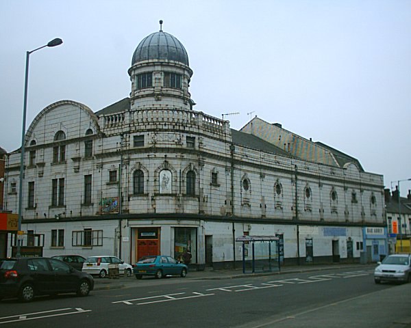
Photo: Captain Scarlet, CC BY 2.5.
Abbeydale Picture House is a former cinema in Sheffield, South Yorkshire, England. When opened by the Lord Mayor of Sheffield on 20 December 1920 the picture house was the largest and most luxurious cinema in Sheffield, often referred to as the "Picture Palace" because of the luxurious cream and gold colour scheme, and dark mahogany seats trimmed with green velvet. Abbeydale Picture House is situated 1,200 feet northwest of CheebaCheeba.
Meersbrook Park
Park

Photo: Windeh, CC BY-SA 3.0.
Meersbrook Park is set on a steep hillside in Meersbrook, Sheffield, England, offering panoramic views over central Sheffield to the north. Within the park are two historic buildings: Bishops' House and Meersbrook Hall. Meersbrook Park is situated 1,200 feet south of CheebaCheeba.
Places in the Area
Nearby places include Meersbrook and Heeley.
Meersbrook
Suburb
Meersbrook is a neighbourhood of the Heeley area in the south-west of Sheffield, England, 2 miles south of the city centre and bordered by Norton Lees to the south and the Meersbrook allotment site to the east.
Heeley
Suburb
Heeley was a cluster of small villages which now form a suburb in the south of the city of Sheffield, South Yorkshire, England. The village has existed at least since 1343, its name deriving from Heah Leah, High Lea then Hely, meaning a high, woodland clearing.
Norton Lees
Suburb
Norton Lees is a residential suburb in the Graves Park ward of the City of Sheffield, England located to the east of Woodseats.
CheebaCheeba
Latitude
53.35683° or 53° 21′ 25″ northLongitude
-1.47643° or 1° 28′ 35″ westOpen location code
9C5W9G4F+PCOpenStreetMap ID
node 8385433165OpenStreetMap feature
amenity=cafeOpenStreetMap attribute
cuisine=coffee_shop
This page is based on OpenStreetMap, Wikidata, and Wikimedia Commons.
We’d love your help improving our open data sources. Thank you for contributing.
Satellite Map
Discover CheebaCheeba from above in high-definition satellite imagery.
Notable Places Nearby
Highlights include Anne’s Community Garden and Meersbrook Park Church.
Nearby Places
Explore places such as Master Barber and Spinning Discs.
England: Must-Visit Destinations
Delve into London, Manchester, Leeds, and York.
Curious Cafés to Discover
Uncover intriguing cafés from every corner of the globe.
About Mapcarta. Data © OpenStreetMap contributors and available under the Open Database License". Text is available under the CC BY-SA 4.0 license, except for photos, directions, and the map. Photo: sidibousaid, CC BY 2.0.