Coppice Food Store
Coppice Food Store is a convenience store in Oldham, England which is located on Chamber Road. Coppice Food Store is situated nearby to Werneth Primary School, as well as near Werneth Cricket Bowling & Tennis Club.| Tap on a place to explore it |
Places of Interest Nearby
Highlights include Our Lady of Mount Carmel and St Patrick Church and Darul Hadis Latifiah Northwest.
Our Lady of Mount Carmel and St Patrick Church
Church
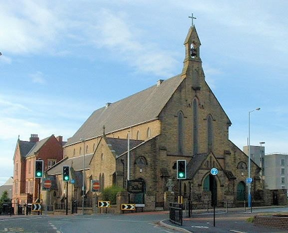
Photo: Wikimedia, CC BY-SA 2.0 uk.
Our Lady of Mount Carmel and St Patrick Church or St Patrick's Church is a Roman Catholic Parish church in Oldham, Greater Manchester, England. It was founded in 1858 and was built in 1870. Our Lady of Mount Carmel and St Patrick Church is situated 2,900 feet north of Coppice Food Store.
Darul Hadis Latifiah Northwest
School
Darul Hadis Latifiah Northwest is an Islamic private school for 11 to 16-year-old boys in Oldham, Greater Manchester, England. It was established in 2012 by parents and community leaders. Darul Hadis Latifiah Northwest is situated 2,200 feet northwest of Coppice Food Store.
Gallery Oldham
Art gallery

Photo: SMJ, CC BY-SA 2.0.
Gallery Oldham is a free-to-view public museum and art gallery in the Cultural Quarter of central Oldham, in Greater Manchester, England. Gallery Oldham is situated 4,200 feet northeast of Coppice Food Store.
Places in the Area
Nearby places include Coppice and Werneth.
Coppice
Suburb
Coppice is a locality and urban/suburban area the town of Oldham, in Greater Manchester, England. It is located to the south of Oldham town centre and is contiguous with other areas of Oldham including Hathershaw, Werneth, Hollins, Copster Hill and Primrose Bank.
Werneth
Suburb

Photo: Alexander P Kapp, CC BY-SA 2.0.
Werneth is an area of Oldham, Greater Manchester, England. The population at the 2011 census was 12,348. It is 1 mile west-southwest of Oldham's commercial centre and one of its most ancient localities.
Copster Hill
Suburb
Copster Hill is a locality in the town of Oldham in Greater Manchester, lying 1.6 miles to the south of Oldham town centre. Archaically a hamlet and private estate set in open moorland and farmland along Hollins Road, the 19th-century growth of Oldham saw Copster Hill form a contiguous urban area with Hathershaw, Hollins, Garden Suburb and Coppice.
Coppice Food Store
- Type: Convenience store
- Address: 169 Chamber Road, Oldham, OL8 1AA
- Categories: shop and food
- Location: Oldham, England, United Kingdom, Britain and Ireland, Europe
- View on OpenStreetMap
Latitude
53.53145° or 53° 31′ 53″ northLongitude
-2.12159° or 2° 7′ 18″ westOpen location code
9C5VGVJH+H9OpenStreetMap ID
node 8417991796OpenStreetMap feature
shop=convenience
This page is based on OpenStreetMap, Wikidata, and Wikimedia Commons.
We’d love your help improving our open data sources. Thank you for contributing.
Satellite Map
Discover Coppice Food Store from above in high-definition satellite imagery.
Notable Places Nearby
Highlights include Werneth Primary School and Werneth Cricket Bowling & Tennis Club.
Nearby Places
Explore places such as Global Travel & Money Transfer and Jaan Boutique.
England: Must-Visit Destinations
Delve into London, Manchester, Sheffield, and Leeds.
Curious Convenience Stores to Discover
Uncover intriguing convenience stores from every corner of the globe.
About Mapcarta. Data © OpenStreetMap contributors and available under the Open Database License". Text is available under the CC BY-SA 4.0 license, except for photos, directions, and the map. Photo: sidibousaid, CC BY 2.0.