Tom Bell Fish And Chips
Tom Bell Fish And Chips is a fast food restaurant in Bromley, Greater London, England. Tom Bell Fish And Chips is situated nearby to the pub The Chancery, as well as near the church St Barnabas.| Tap on a place to explore it |
Places of Interest Nearby
Highlights include The Chancery and St Barnabas.

St Barnabas
Church

Photo: David Anstiss, CC BY-SA 2.0.
St Barnabas is a church, which is situated 950 feet southeast of Tom Bell Fish And Chips.
Beckenham Junction station
Railway station

Photo: Sunil060902, CC BY-SA 3.0.
Beckenham Junction is the main railway and tram station in Beckenham in the London Borough of Bromley, south London. The railway stop is on the Chatham Main Line, 8 miles 53 chains down the line from London Victoria and situated between Kent House and Shortlands. Beckenham Junction station is situated 2,500 feet northwest of Tom Bell Fish And Chips.
Places in the Area
Nearby places include Beckenham and Shortlands.
Beckenham
Suburb
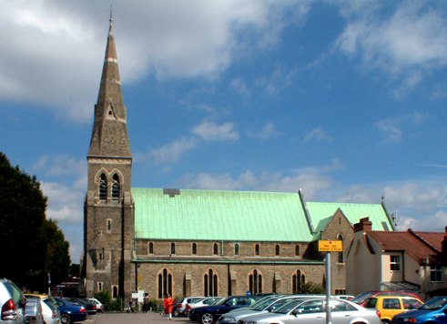
Photo: Philip Talmage, CC BY-SA 2.0.
Beckenham is a town in Greater London, England, within the London Borough of Bromley. Prior to 1965, it was part of Kent. It is situated north of Elmers End and Eden Park, east of Penge, south of Lower Sydenham and Bellingham, and west of Bromley and Shortlands, and 8.4 miles south-east of Charing Cross.
Shortlands
Suburb
Shortlands is a suburb of South East London, England, within the London Borough of Bromley. It has been part of Greater London since 1965, and was previously part of the historic county of Kent. It is located between west of Bromley and east of Beckenham.
Eden Park
Suburb

Photo: Dr Neil Clifton, CC BY-SA 2.0.
Eden Park is a suburban area in Greater London, England, within the London Borough of Bromley, Greater London and prior to 1965, in the historic county of Kent.
Tom Bell Fish And Chips
- Type: Fast food restaurant
- Cuisine: fish and chips
- Categories: food and restaurant
- Location: Bromley, Greater London, England, United Kingdom, Britain and Ireland, Europe
- View on OpenStreetMap
Latitude
51.40681° or 51° 24′ 25″ northLongitude
-0.01714° or 0° 1′ 2″ westOpen location code
9C3XCX4M+P4OpenStreetMap ID
node 8437637462OpenStreetMap feature
amenity=fast_foodOpenStreetMap attribute
cuisine=fish_and_chips
This page is based on OpenStreetMap, Wikidata, and Wikimedia Commons.
We’d love your help improving our open data sources. Thank you for contributing.
Satellite Map
Discover Tom Bell Fish And Chips from above in high-definition satellite imagery.
Notable Places Nearby
Highlights include St Christophers The Hall School and Clare House Primary School.
Nearby Places
Explore places such as Beckenham Off Licence and Varley & Varley.
England: Must-Visit Destinations
Delve into London, Manchester, Sheffield, and Leeds.
Curious Fast Food Restaurants to Discover
Uncover intriguing fast food restaurants from every corner of the globe.
About Mapcarta. Data © OpenStreetMap contributors and available under the Open Database License". Text is available under the CC BY-SA 4.0 license, except for photos, directions, and the map. Photo: Mario modesto, CC BY-SA 3.0.