Das Kropsche Feld
Das Kropsche Feld is a locality in Kleve, Düsseldorf, North Rhine-Westphalia. Das Kropsche Feld is situated nearby to the locality Kiwesfeld, as well as near the village Warbeyen.| Tap on a place to explore it |
Places of Interest
Highlights include Emmerich Rhine Bridge and Rheinmuseum Emmerich.
Emmerich Rhine Bridge
Bridge

Photo: Wikimedia, CC BY-SA 4.0.
The Emmerich Rhine Bridge is a suspension bridge located in Emmerich am Rhein, Germany. Completed in 1965, it has a main span of 500 metres, crossing the Rhine, carrying the Bundesstraße B 220, the federal highway between Emmerich am Rhein and Kleve.
Rheinmuseum Emmerich
Museum
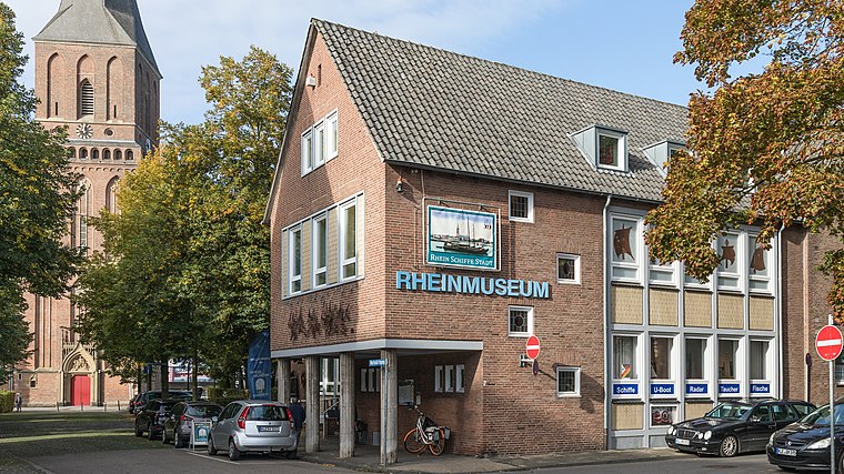
Photo: Wikimedia, CC BY-SA 4.0.
Rheinmuseum Emmerich is situated 3 km northeast of Das Kropsche Feld.
Stadtbücherei Emmerich
Library

Photo: Wikimedia, CC BY-SA 3.0.
Stadtbücherei Emmerich is a library, which is situated 3 km northeast of Das Kropsche Feld.
Places in the Area
Nearby places include Emmerich am Rhein and Griethausen.
Emmerich am Rhein

Photo: Maparial, CC BY-SA 3.0.
Emmerich am Rhein is a city on the River Rhine in Lower Rhine in the state of North Rhine-Westphalia in Germany, with a population of around 30,000.
Griethausen
Village
Griethausen is a village and former city in the municipality of Kleve, Kreis Kleve in the German State of North Rhine-Westphalia. The village is located at the Griethauser Altrhein. Griethausen is situated 3½ km northwest of Das Kropsche Feld.
Qualburg
Village
Photo: MiraculixHB, Public domain.
Qualburg is a village, which is situated 4 km southwest of Das Kropsche Feld.
Das Kropsche Feld
- Type: Locality
- Location: Kleve, Kleve, Düsseldorf, Lower Rhine, North Rhine-Westphalia, Germany, Central Europe, Europe
- View on OpenStreetMap
Latitude
51.80872° or 51° 48′ 31″ northLongitude
6.21063° or 6° 12′ 38″ eastOpen location code
9F38R656+F7OpenStreetMap ID
node 8517847106OpenStreetMap feature
place=locality
This page is based on OpenStreetMap, Wikidata, and Wikimedia Commons.
We’d love your help improving our open data sources. Thank you for contributing.
Satellite Map
Discover Das Kropsche Feld from above in high-definition satellite imagery.
Localities in the Area
Explore places such as Kiwesfeld and Warbeyen.
Notable Places Nearby
Highlights include Spielplatz Huisberdener Straße (Warbeyen) and Freiwillige Feuerwehr Kleve Löschgruppe Warbeyen.
Lower Rhine: Must-Visit Destinations
Delve into Düsseldorf, Mönchengladbach, Krefeld, and Neuss.
Curious Localities to Discover
Uncover intriguing localities from every corner of the globe.
About Mapcarta. Data © OpenStreetMap contributors and available under the Open Database License". Text is available under the CC BY-SA 4.0 license, except for photos, directions, and the map. Photo: Orange2000, CC BY-SA 4.0.