Embassy of Finland
Embassy of Finland is a government office in Mexico State, Central Mexico which is located on Calle Monte Pelvoux. Embassy of Finland is situated nearby to the fountain Fuente de Petróleos, as well as near the building Súper Servicio Lomas.| Tap on a place to explore it |
Photo: Aquintero82, CC BY-SA 4.0.
- Type: Government office
- Description: Embassy of Finland in México City, Mexico
- Also known as: “Embajada de Finlandia” and “Embassy of Finland in Mexico”
- Address: 111 Calle Monte Pelvoux
Places of Interest Nearby
Highlights include Embassy of Ireland and National Museum of Anthropology.
Embassy of Ireland
Government office

Photo: Aquintero82, CC BY-SA 4.0.
Embassy of Ireland is a government office, which is situated 610 metres northeast of Embassy of Finland.
National Museum of Anthropology
Museum
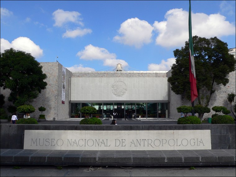
Photo: Wikimedia, CC BY-SA 3.0.
The National Museum of Anthropology is a national museum of Mexico. It is the largest and most visited museum in Mexico. Located in the area between Paseo de la Reforma and Mahatma Gandhi Street within Chapultepec Park in Mexico City, the museum contains… National Museum of Anthropology is situated 2 km east of Embassy of Finland.
Torre Virreyes

Photo: Juan Carlos Fonseca Mata, CC BY-SA 4.0.
Torre Virreyes is situated 190 metres south of Embassy of Finland.
Places in the Area
Nearby places include Polanco and Nuevo Polanco.
Polanco

Photo: Matthew Rutledge, CC BY 2.0.
Polanco refers to an area of Mexico City north of Chapultepec Park. This district is delimited by Paseo de la Reforma to the south, Boulevard Manuel Avila Camacho to the west, Avenida Ejercito Nacional to the north and Avenida Mariano Escobedo to the east.
Nuevo Polanco
Quarter

Photo: Wikimedia, CC BY-SA 3.0.
Nuevo Polanco is an area of Mexico City formerly consisting of warehouses and factories, bordering the upscale Polanco on the north across Avenida Ejército Nacional.
San Miguel Chapultepec
Quarter

Photo: Wikimedia, CC BY-SA 2.0.
San Miguel Chapultepec is a colonia or neighborhood in Delegación Miguel Hidalgo in Mexico City. Its borders are: The colonia's streets carry the names of generals and governors of Mexico. San Miguel Chapultepec is situated 2½ km southeast of Embassy of Finland.
Embassy of Finland
- Categories: embassy, office, and government building
- Location: Mexico State, Central Mexico, Mexico, North America
- View on OpenStreetMap
Latitude
19.42654° or 19° 25′ 36″ northLongitude
-99.20369° or 99° 12′ 13″ westOpen location code
76F2CQGW+JGOpenStreetMap ID
node 8569021491OpenStreetMap feature
office=diplomaticWikidata ID
Q106240474
This page is based on OpenStreetMap, Wikidata, and Wikimedia Commons.
We’d love your help improving our open data sources. Thank you for contributing.
Satellite Map
Discover Embassy of Finland from above in high-definition satellite imagery.
In Other Languages
From Asturian to Turkish—“Embassy of Finland” goes by many names.
- Asturian: “embaxada de Finlandia en Méxicu”
- Catalan: “Ambaixada de Finlàndia a Ciutat de Mèxic”
- Finnish: “Suomen Méxicon-suurlähetystö”
- Finnish: “Suomen suurlähetystö, Mexico”
- Finnish: “Suomen suurlähetystö”
- French: “ambassade de Finlande au Mexique”
- French: “Ambassade de Finlande”
- German: “Botschaft von Finnland in Mexiko”
- Spanish: “embajada de Finlandia en México”
- Spanish: “Embajada de Finlandia en México”
- Swedish: “Finlands ambassad i Mexiko”
- Swedish: “Finlands ambassad”
- Turkish: “Finlandiya’nın Meksika Büyükelçiliği”
Places with the Same Name
Discover other places named “Embassy of Finland”.
Notable Places Nearby
Highlights include Fuente de Petróleos and Súper Servicio Lomas.
Nearby Places
Explore places such as BBVA and Petróleos Mexicanos.
Mexico State: Must-Visit Destinations
Delve into Tequixquiac, Toluca, Teotihuacan, and Ecatepec.
Curious Government Offices to Discover
Uncover intriguing government offices from every corner of the globe.
About Mapcarta. Data © OpenStreetMap contributors and available under the Open Database License". Text is available under the CC BY-SA 4.0 license, except for photos, directions, and the map. Photo: Aquintero82, CC BY-SA 4.0.