Prinz-Carl-Anlage
Prinz-Carl-Anlage is a bike rental in Worms, Rhenish Hesse, Rhineland-Palatinate. Prinz-Carl-Anlage is situated nearby to the hotel building Parkhotel Prinz Carl, as well as near Freie evangelische Gemeinde.| Tap on a place to explore it |
Places of Interest Nearby
Highlights include Worms Hauptbahnhof and Lukaskirche.
Worms Hauptbahnhof
Railway station

Photo: Jivee Blau, CC BY-SA 3.0.
Worms Hauptbahnhof is, along with Worms Pfeddersheim station, one of two operational passenger stations in the Rhenish Hesse city of Worms, Germany. The station with its pedestrian underpass is also an essential link between the eastern and the western parts of central Worms. Worms Hauptbahnhof is situated 610 metres southwest of Prinz-Carl-Anlage.
Lukaskirche
Church

Photo: Tonialsa, CC BY-SA 4.0.
Lukaskirche is a church, which is situated 350 metres northeast of Prinz-Carl-Anlage.
Worms Cathedral
Church
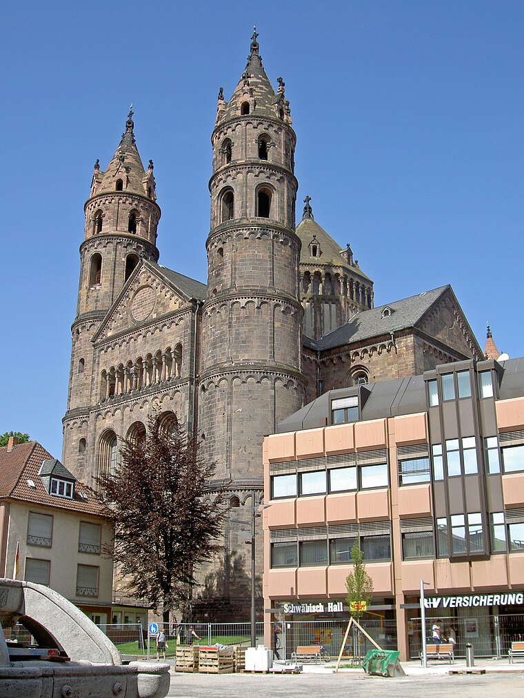
Photo: Wikimedia, CC BY-SA 3.0.
St Peter's Cathedral is a Roman Catholic church and former cathedral in Worms, southern Germany. The cathedral is located on the highest point of the inner city of Worms and is the most important building of the Romanesque style in Worms. Worms Cathedral is situated 1 km south of Prinz-Carl-Anlage.
Places in the Area
Nearby places include Hochheim and Pfiffligheim.

Pfiffligheim
Suburb

Photo: Jivee Blau, CC BY-SA 3.0.
Pfiffligheim is a suburb, which is situated 3 km west of Prinz-Carl-Anlage.
Herrnsheim
Suburb

Photo: PQ3, CC BY-SA 3.0.
Herrnsheim is a suburb, which is situated 3 km northwest of Prinz-Carl-Anlage.
Prinz-Carl-Anlage
- Type: Bike rental
- Category: transportation
- Location: Worms, Rhenish Hesse, Rhineland-Palatinate, Germany, Central Europe, Europe
- View on OpenStreetMap
Latitude
49.63992° or 49° 38′ 24″ northLongitude
8.36097° or 8° 21′ 40″ eastBrand
VRNnextbikeOperator
NextbikeNetwork
VRNnextbikeOpen location code
8FXCJ9Q6+X9OpenStreetMap ID
node 8909939256OpenStreetMap feature
amenity=bicycle_rental
This page is based on OpenStreetMap, Wikidata, and Wikimedia Commons.
We’d love your help improving our open data sources. Thank you for contributing.
Satellite Map
Discover Prinz-Carl-Anlage from above in high-definition satellite imagery.
Notable Places Nearby
Highlights include Parkhotel Prinz Carl and Freie evangelische Gemeinde.
Nearby Places
Explore places such as Worms, Prinz-Carl-Anlage and Dormero Hotel Worms.
Rhenish Hesse: Must-Visit Destinations
Delve into Mainz, Bingen, Ingelheim, and Oppenheim.
Curious Bike Rentals to Discover
Uncover intriguing bike rentals from every corner of the globe.
About Mapcarta. Data © OpenStreetMap contributors and available under the Open Database License". Text is available under the CC BY-SA 4.0 license, except for photos, directions, and the map. Photo: Pratz53, CC BY-SA 4.0.