Old Man Thames
Old Man Thames is a work of art in Richmond upon Thames, Greater London, England. Old Man Thames is situated nearby to the park Terrace Gardens Richmond, as well as near the fountain Bulbous Betty.| Tap on a place to explore it |
Places of Interest Nearby
Highlights include Terrace Gardens Richmond and Richmond Bridge.

Richmond Bridge
Bridge

Photo: Amandajm, CC BY-SA 3.0.
Richmond Bridge is an 18th-century stone arch bridge that crosses the River Thames at Richmond, connecting the two halves of the present-day London Borough of Richmond upon Thames. Richmond Bridge is situated 1,900 feet northwest of Old Man Thames.
Glover’s Island
Islet

Photo: Motmit, CC BY-SA 3.0.
Glover’s Island is a small island in a tree-lined section of the Thames River, known as Horse Reach on the tidal Thames, between Richmond Lock and Teddington Lock in the Borough of Richmond upon Thames, London, England.
Places in the Area
Nearby places include Richmond and Petersham.
Richmond
Town
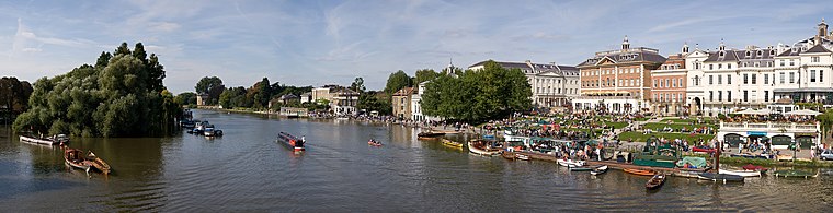
Photo: Diliff, CC BY-SA 3.0.
Richmond is a town in south-west London, 8.2 miles west-south-west of Charing Cross. It stands on the River Thames, and features many parks and open spaces, including Richmond Park, and many protected conservation areas, which include much of Richmond Hill.
Petersham
Suburb

Photo: Stephen Craven, CC BY-SA 2.0.
Petersham is a village in the London Borough of Richmond upon Thames on the east of the bend in the River Thames south of Richmond, which it shares with neighbouring Ham.
St Margarets
Suburb

Photo: David Kemp, CC BY-SA 2.0.
St Margarets is an affluent suburb and neighbourhood in the London Borough of Richmond upon Thames, about 9 miles west-southwest of central London. It is bounded by the Thames Tideway to the north-east, and the River Crane to the north-west and north where the land tapers between those rivers.
Old Man Thames
- Type: Work of art
- Artwork type: statue
- Category: tourism
- Location: Richmond upon Thames, Greater London, England, United Kingdom, Britain and Ireland, Europe
- View on OpenStreetMap
Latitude
51.45356° or 51° 27′ 13″ northLongitude
-0.30154° or 0° 18′ 6″ westOpen location code
9C3XFM3X+C9OpenStreetMap ID
node 9039220740OpenStreetMap feature
tourism=artworkOpenStreetMap attribute
artwork_type=statue
This page is based on OpenStreetMap, Wikidata, and Wikimedia Commons.
We’d love your help improving our open data sources. Thank you for contributing.
Satellite Map
Discover Old Man Thames from above in high-definition satellite imagery.
Notable Places Nearby
Highlights include Bulbous Betty and Richmond Canoe Club.
Nearby Places
Explore places such as Hollyhock Cafe and Glasshouse.
England: Must-Visit Destinations
Delve into London, Manchester, Sheffield, and Leeds.
Curious Work Of Arts to Discover
Uncover intriguing work of arts from every corner of the globe.
About Mapcarta. Data © OpenStreetMap contributors and available under the Open Database License". Text is available under the CC BY-SA 4.0 license, except for photos, directions, and the map. Photo: sidibousaid, CC BY 2.0.