The Petra Park Map
The Petra Park Map is in Ma’an Governorate, Jordan. The Petra Park Map is situated nearby to Petra Museum, as well as near the bus station JETT bus terminal.| Tap on a place to explore it |
Places of Interest Nearby
Highlights include The Treasury (Al-Khazneh) and Vaux Moise.
The Treasury (Al-Khazneh)
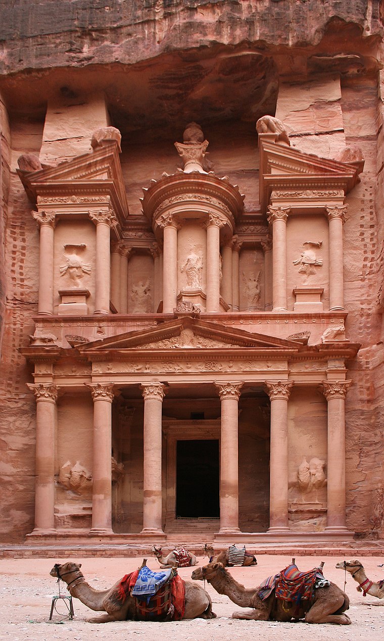
Photo: Graham Racher, CC BY-SA 2.0.
Al-Khazneh, also known as Khazneh el-Far'oun, is one of the most elaborate rock-cut tombs in Petra, a city of the Nabatean Kingdom inhabited by the Arabs in ancient times. The Treasury (Al-Khazneh) is situated 1½ km west of The Petra Park Map.
Vaux Moise
Castle
Wu'ayra Castle is a ruined Crusader castle located in Wadi Musa, Jordan, 1 kilometre north of the main entrance to Petra. It was founded by Baldwin I of Jerusalem as an outpost of the larger Montreal Castle, which stands about 34 kilometres north of it at Shoubak. Vaux Moise is situated 1 km north of The Petra Park Map.
Jebel al-Madhbah
Peak

Photo: Jeanhousen, CC BY-SA 3.0.
Jebel al-Madhbah is a mountain at Petra, Jordan, at whose peak there is a large Nabataean ritual site centered around an altar.
Places in the Area
Nearby places include Petra and Petra.
Petra

Photo: Faraheed, CC BY-SA 3.0.
Petra, the fabled "rose red city, half as old as time", is a well known ancient Nabataean city in the south of Jordan. Due to its breathtaking grandeur and fabulous ruins, Petra was recognised as a World Heritage Site by UNESCO in 1985.
Petra
Town

Photo: Ji-Elle, CC BY-SA 4.0.
Wadi Musa is a town located in the Ma'an Governorate in southern Jordan. It is the administrative center of the Petra Department and the nearest town to the archaeological site of Petra, being only 3.5 km away.
The Petra Park Map
- Type: Map
- Categories: information and tourism
- Location: Ma’an Governorate, Jordan, Middle East, Asia
- View on OpenStreetMap
Latitude
30.32447° or 30° 19′ 28″ northLongitude
35.46774° or 35° 28′ 4″ eastOpen location code
8G2Q8FF9+Q3OpenStreetMap ID
node 9244111330OpenStreetMap feature
tourism=information
This page is based on OpenStreetMap, Wikidata, and Wikimedia Commons.
We’d love your help improving our open data sources. Thank you for contributing.
Satellite Map
Discover The Petra Park Map from above in high-definition satellite imagery.
Notable Places Nearby
Highlights include Petra Museum and JETT bus terminal.
Nearby Places
Explore places such as The Petra Park Map and Petra Tourist Information Center;Visitor Center and museum.
Curious Places to Discover
Uncover intriguing places from every corner of the globe.
About Mapcarta. Data © OpenStreetMap contributors and available under the Open Database License". Text is available under the CC BY-SA 4.0 license, except for photos, directions, and the map. Photo: Wikimedia, CC0.