L’Ans’oleillé
L’Ans’oleillé is a fast food restaurant in Guadeloupe which is located on Route de l’Anse Rodrigue. L’Ans’oleillé is situated nearby to the beach Plage d’Anse Rodrigue, as well as near the peak Morne Rodriguez.| Tap on a place to explore it |
- Type: Fast food restaurant
- Cuisine: Caribbean
- Address: Route de l’Anse Rodrigue, 97137
Places of Interest Nearby
Highlights include Morne à Craie and Les Saintes Airport.
Morne à Craie
Peak

Photo: Patrice78500, CC BY-SA 3.0.
Morne à Craie is a mountain on the island of Terre-de-Haut in the archipelago of the Îles des Saintes in Guadeloupe. It has an altitude of 148 metres. The south side of the mountain is a classified natural area of ecological interest for its flora and fauna, and was acquired in 2003 by the Conservatoire du Littoral.
Les Saintes Airport
Aerodrome
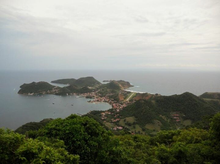
Photo: Moowgly, CC BY-SA 3.0.
Les Saintes Airport is an airport serving the archipelago of Îles des Saintes, French West Indies. It is on an isthmus in the middle of Terre-de-Haut Island, a dependency of Guadeloupe. A special pilot license endorsement is required to land here.
Notre Dame de l’Assomption, les Saintes
Church

Photo: UHF, CC BY-SA 3.0.
Notre-Dame de l'Assomption is a Roman Catholic Church of the Îles des Saintes, an island in the archipelago of the French Overseas department of Guadeloupe. Notre Dame de l’Assomption, les Saintes is situated 1 km north of L’Ans’oleillé.
Places in the Area
Nearby places include Grande-Anse and La Savane.
Grande-Anse
Neighborhood

Photo: Patrice78500, CC BY-SA 3.0.
Grande-Anse is a quartier of Terre-de-Haut Island, located in Îles des Saintes archipelago in the Caribbean. It is located in the eastern part of the island.
La Savane
Neighborhood
La Savane is a quartier of Terre-de-Haut Island, located in Îles des Saintes archipelago in the Caribbean. It is a residential area located in the central part of the island.
Fond-du-Curé
Neighborhood

Photo: Patrice78500, CC BY-SA 3.0.
Fond-du-Curé is a quartier of Terre-de-Haut Island, located in Les Saintes, Guadeloupe. It is located in the central part of the island. This is the main village of Terre-de-Haut Island.
L’Ans’oleillé
- Categories: food and restaurant
- Location: Guadeloupe, Lesser Antilles, Caribbean, North America
- View on OpenStreetMap
Latitude
15.85892° or 15° 51′ 32″ northLongitude
-61.57952° or 61° 34′ 46″ westOpen location code
777WVC5C+H5OpenStreetMap ID
node 9469153417OpenStreetMap feature
amenity=fast_foodOpenStreetMap attribute
cuisine=caribbean
This page is based on OpenStreetMap, Wikidata, and Wikimedia Commons.
We’d love your help improving our open data sources. Thank you for contributing.
Satellite Map
Discover L’Ans’oleillé from above in high-definition satellite imagery.
Notable Places Nearby
Highlights include Plage d’Anse Rodrigue and Morne Rodriguez.
Nearby Places
Explore places such as Anse Rodrigue and Villa Praia.
Guadeloupe: Must-Visit Destinations
Delve into Pointe-à-Pitre, Sainte-Anne, Basse-Terre, and Grande-Terre.
Curious Fast Food Restaurants to Discover
Uncover intriguing fast food restaurants from every corner of the globe.
About Mapcarta. Data © OpenStreetMap contributors and available under the Open Database License". Text is available under the CC BY-SA 4.0 license, except for photos, directions, and the map. Photo: Patrice78500, CC BY-SA 3.0.