Krasnogornyatskiy
Krasnogornyatskiy is a village in Rostov Oblast, Southern Russia and has about 1,750 residents. Krasnogornyatskiy is situated nearby to the village Заречный, as well as near Zarechnyi.| Tap on a place to explore it |
- Type: Village with 1,750 residents
- Description: human settlement in Oktyabrsky District, Rostov Oblast, Rostov Oblast, Russia
- Address: Октябрьский район
Places of Interest
Highlights include Church of Michael the Archangel.
Church of Michael the Archangel
Church

Photo: Astr72, CC BY-SA 3.0.
The Church of Michael the Archangel is a Russian Orthodox church in the urban-type settlement of Kamenolomni, Oktyabrsky District, Rostov Oblast, Russia. It belongs to the Nizhnedonsky Deanery of Shakhty and Millerovo Diocese of Moscow Patriarchate.
Places in the Area
Nearby places include Kamenolomni.
Kamenolomni
Town
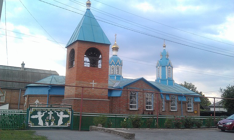
Photo: Astr72, CC BY-SA 3.0.
Kamenolomni is an urban locality in Oktyabrsky District of Rostov Oblast, Russia. Population: 11,247 ; 12,281 ; 12,410 .
Krasnogornyatskiy
- Categories: posyolok and locality
- Location: Rostov Oblast, Southern Russia, Russia, Eastern Europe, Europe
- View on OpenStreetMap
Latitude
47.65236° or 47° 39′ 9″ northLongitude
40.20118° or 40° 12′ 4″ eastPopulation
1,750Open location code
8HV2M622+WFOpenStreetMap ID
node 959224481OpenStreetMap feature
place=villageWikidata ID
Q4238457
This page is based on OpenStreetMap, Wikidata, and Wikimedia Commons.
We’d love your help improving our open data sources. Thank you for contributing.
Satellite Map
Discover Krasnogornyatskiy from above in high-definition satellite imagery.
In Other Languages
From Armenian to Ukrainian—“Krasnogornyatskiy” goes by many names.
- Armenian: “Կրասնոգորնյացկի (Օկտյաբրսկի շրջան)”
- Armenian: “Կրասնոգորնյացկի”
- Chechen: “Красногорняцки”
- Chechen: “Красногорняцкий”
- German: “Krasnogornjazki”
- Russian: “Красногорняцкий (Октябрьский район)”
- Russian: “Красногорняцкий”
- Ukrainian: “Красногорняцький”
Localities in the Area
Explore places such as Заречный and Zarechnyi.
Notable Places Nearby
Highlights include Отделение почтовой связи Красногорняцкий 346474 and Каменоломни.
Curious Villages to Discover
Uncover intriguing villages from every corner of the globe.
About Mapcarta. Data © OpenStreetMap contributors and available under the Open Database License". Text is available under the CC BY-SA 4.0 license, except for photos, directions, and the map. Photo: Ymblanter, CC BY-SA 4.0.