Weaste
Weaste is a station in Salford, England. Weaste is situated nearby to Tootal Drive Post Office, as well as near St Luke’s Church, Pendleton.| Tap on a place to explore it |
Places of Interest Nearby
Highlights include St Luke’s Church, Pendleton and Weaste Cemetery.
St Luke’s Church, Pendleton
Church

Photo: Plucas58, CC BY-SA 3.0.
St Luke's Church is an Anglican church that stands on raised ground in Liverpool Street, Pendleton, Salford. The church, in the parish of Weaste, Seedley and Langworthy, is part of the Salford All Saints Team Ministry in the Salford deanery and the Manchester diocese. St Luke’s Church, Pendleton is situated 1,200 feet northeast of Weaste.
Weaste Cemetery
Cemetery

Photo: Eirian Evans, CC BY-SA 2.0.
Weaste Cemetery, previously known as Salford Borough Cemetery, is a public Grade II listed Victorian cemetery in Weaste, Salford. Opened in 1857, it is the oldest of Salford's four cemeteries, covering 39 acres and containing over 332,000 graves. Weaste Cemetery is situated 2,000 feet southeast of Weaste.
Imperial War Museum North
Museum
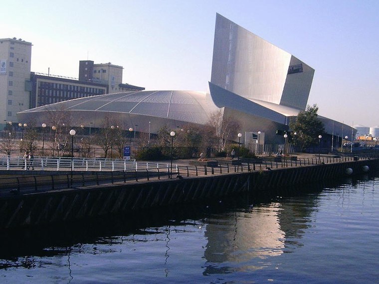
Photo: pit-yacker, CC BY-SA 2.0.
Imperial War Museum North is a museum in the Metropolitan Borough of Trafford in Greater Manchester, England. One of five branches of the Imperial War Museum, it explores the impact of modern conflicts on people and society. Imperial War Museum North is situated 1 mile south of Weaste.
Places in the Area
Nearby places include Weaste and Seedley.
Weaste
Suburb
Weaste is an inner-city suburb of Salford, Greater Manchester, England. It is bordered by the town of Eccles to the West and Seedley to the East. In 2014 Weaste and Seedley ward had a population of 12,616.
MediaCityUK
Neighborhood

Photo: Briangeorge1945, CC BY-SA 4.0.
MediaCityUK is a 200-acre mixed-use property development on the banks of the Manchester Ship Canal in Salford, Greater Manchester, England. The project was developed by Peel Media; its principal tenants are media organisations and the Quayside MediaCityUK shopping centre.
Weaste
- Type: Station
- Category: transportation
- Location: Salford, England, United Kingdom, Britain and Ireland, Europe
- View on OpenStreetMap
Latitude
53.48241° or 53° 28′ 57″ northLongitude
-2.30746° or 2° 18′ 27″ westOpen location code
9C5VFMJV+X2OpenStreetMap ID
node 9709653466OpenStreetMap feature
public_transport=station
This page is based on OpenStreetMap, Wikidata, and Wikimedia Commons.
We’d love your help improving our open data sources. Thank you for contributing.
Satellite Map
Discover Weaste from above in high-definition satellite imagery.
Places with the Same Name
Discover other places named “Weaste”.
Notable Places Nearby
Highlights include Tootal Drive Post Office and Saint Lukes.
Nearby Places
Explore places such as Weaste and Eccles New Road/Weaste Tram Stop.
England: Must-Visit Destinations
Delve into London, Manchester, Sheffield, and Leeds.
Curious Stations to Discover
Uncover intriguing stations from every corner of the globe.
About Mapcarta. Data © OpenStreetMap contributors and available under the Open Database License". Text is available under the CC BY-SA 4.0 license, except for photos, directions, and the map. Photo: Craig Sunter, CC BY 2.0.