Zweite Begütengewanne
Zweite Begütengewanne is a locality in Rhineland-Palatinate, Germany. Zweite Begütengewanne is situated nearby to the locality Dritte Begütengewanne, as well as near Erste Begütengewanne.| Tap on a place to explore it |
Places of Interest
Highlights include Melm and Ludwigshafen-Oggersheim station.

Ludwigshafen-Oggersheim station
Railway station
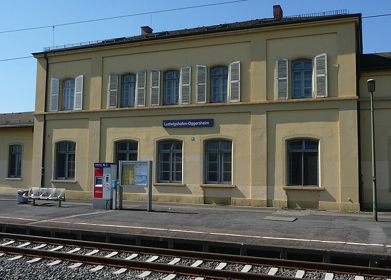
Photo: Immanuel Giel, Public domain.
Ludwigshafen-Oggersheim station is a railway station.
Places in the Area
Nearby places include Hemshof and Eppstein.
Hemshof
Suburb
Hemshof is one of the oldest city districts of Ludwigshafen Am Rhein, Germany. It is located above the "Nord" district. The first settlement in Hemshof is believed to have been built by the Celts in 516, not as a city but as a small farm. Hemshof is situated 3½ km southeast of Zweite Begütengewanne.
Eppstein
Suburb
Photo: Immanuel Giel, CC BY-SA 3.0.
Eppstein is a suburb, which is situated 4 km west of Zweite Begütengewanne.
Pfingstweide
Suburb

Photo: Immanuel Giel, Public domain.
Pfingstweide is a suburb, which is situated 4 km north of Zweite Begütengewanne.
Zweite Begütengewanne
- Type: Locality
- Location: Rhineland-Palatinate, Germany, Central Europe, Europe
- View on OpenStreetMap
Latitude
49.50212° or 49° 30′ 8″ northLongitude
8.38502° or 8° 23′ 6″ eastOpen location code
8FXCG92P+R2OpenStreetMap ID
node 9781073448OpenStreetMap feature
place=locality
This page is based on OpenStreetMap, Wikidata, and Wikimedia Commons.
We’d love your help improving our open data sources. Thank you for contributing.
Satellite Map
Discover Zweite Begütengewanne from above in high-definition satellite imagery.
Localities in the Area
Explore places such as Dritte Begütengewanne and Erste Begütengewanne.
Notable Places Nearby
Highlights include Begütenweiher and ASV Petri Heil Oggersheim 1930.
Rhineland-Palatinate: Must-Visit Destinations
Delve into Mainz, Trier, Koblenz, and Worms.
Curious Localities to Discover
Uncover intriguing localities from every corner of the globe.
About Mapcarta. Data © OpenStreetMap contributors and available under the Open Database License". Text is available under the CC BY-SA 4.0 license, except for photos, directions, and the map. Photo: Traveler100, CC BY-SA 3.0.