Tabley Hill Service Station
Tabley Hill Service Station is a commercial area in Tabley Superior, Cheshire East, England. Tabley Hill Service Station is situated nearby to St Paul’s Church, Over Tabley, as well as near the forest Belt Wood.| Tap on a place to explore it |
Places of Interest Nearby
Highlights include St Paul’s Church, Over Tabley and Knutsford railway station.
St Paul’s Church, Over Tabley
Church

Photo: Iain Lees, CC BY-SA 2.0.
St Paul's Church, is in Tabley Superior, Cheshire, England. It stands beside the B5569 which was formerly the A556 road between the M6 and the M56 but was bypassed by the new A556 road to the west in 2017. St Paul’s Church, Over Tabley is situated 2,300 feet north of Tabley Hill Service Station.
Knutsford railway station
Railway station
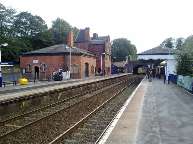
Photo: Glyn Baker, CC BY-SA 2.0.
Knutsford railway station serves the town of Knutsford in Cheshire, England. The station is 21+3⁄4 miles south of Manchester Piccadilly on the Mid-Cheshire Line to Chester. Knutsford railway station is situated 2 miles east of Tabley Hill Service Station.
Tatton Hall

Photo: K. Whatley, CC BY-SA 2.0.
Tatton Hall is a country house in Tatton Park near Knutsford, Cheshire, England. It is designated as a Grade I listed building and is open to the public. Tatton Hall is situated 2 miles northeast of Tabley Hill Service Station.
Places in the Area
Nearby places include Knutsford and Lostock Gralam.
Knutsford
 Knutsford is a very pleasant town of 13,000 people in Cheshire spoilt only by its position under Manchester Airport's flight path.
Lostock Gralam
Village

Photo: Ian Warburton, CC BY-SA 2.0.
Lostock Gralam is a village and civil parish in Cheshire West and Chester, Cheshire, England; it is sited east of Northwich. The civil parish also includes the small hamlet of Lostock Green. At the 2011 census, the population was 2,298. Lostock Gralam is situated 3½ miles southwest of Tabley Hill Service Station.
Great Budworth
Village

Photo: Joopercoopers, CC BY-SA 3.0.
Great Budworth is a village and civil parish in Cheshire, England, four miles north of Northwich off the A559 road, east of Comberbach, northwest of Higher Marston and southeast of Budworth Heath. Great Budworth is situated 4 miles west of Tabley Hill Service Station.
Tabley Hill Service Station
- Type: Commercial area
- Location: Tabley Superior, Cheshire East, England, United Kingdom, Britain and Ireland, Europe
- View on OpenStreetMap
Latitude
53.31008° or 53° 18′ 36″ northLongitude
-2.41708° or 2° 25′ 2″ westOpen location code
9C5V8H6M+25OpenStreetMap ID
way 1008811502OpenStreetMap feature
highway=servicesOpenStreetMap feature
landuse=retail
This page is based on OpenStreetMap, Wikidata, and Wikimedia Commons.
We’d love your help improving our open data sources. Thank you for contributing.
Satellite Map
Discover Tabley Hill Service Station from above in high-definition satellite imagery.
Notable Places Nearby
Highlights include Belt Wood and Black Clump.
Nearby Places
Explore places such as Esso and Londis.
England: Must-Visit Destinations
Delve into London, Manchester, Sheffield, and Leeds.
Curious Commercial Areas to Discover
Uncover intriguing commercial areas from every corner of the globe.
About Mapcarta. Data © OpenStreetMap contributors and available under the Open Database License". Text is available under the CC BY-SA 4.0 license, except for photos, directions, and the map. Photo: sidibousaid, CC BY 2.0.