Eurospital
Eurospital is in San Dorligo della Valle, Province of Trieste, Friuli-Venezia Giulia. Eurospital is situated nearby to the post office GLS, as well as near the government office Agenzia Monopoli.| Tap on a place to explore it |
Places of Interest Nearby
Highlights include Risiera di San Sabba and Stadio Giuseppe Grezar.
Risiera di San Sabba
 Risiera di San Sabba was a Nazi concentration camp operating in Trieste. Officially designated as a police detention camp, it was the only one on Italian territory with a crematorium. Risiera di San Sabba is situated 2½ km northwest of Eurospital.
Stadio Giuseppe Grezar
Sports venue
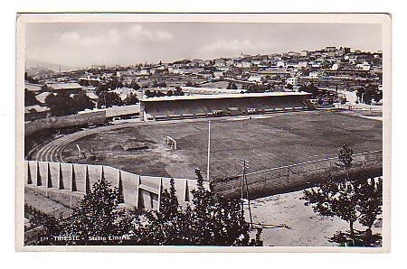
Photo: Wikimedia, Public domain.
Stadio Giuseppe Grezar is a multi-use stadium in Trieste, Italy. It was inaugurated in 1932 as the Stadio Littorio and was initially used as the stadium of U.S. Stadio Giuseppe Grezar is situated 2½ km northwest of Eurospital.
Stadio Nereo Rocco
Sports venue

Photo: EneaBalsoldo, CC BY-SA 4.0.
Stadio Nereo Rocco is a football stadium in Trieste, Italy. Opened in 1992, it is the home of Triestina, named after the club's former player and manager Nereo Rocco. Stadio Nereo Rocco is situated 2½ km northwest of Eurospital.
Places in the Area
Nearby places include Borgo San Sergio and San Giuseppe della Chiusa.
San Giuseppe della Chiusa
Village

Photo: Betta27, CC BY-SA 3.0.
San Giuseppe della Chiusa is a village.
Caresana
Village

Photo: Betta27, CC BY-SA 3.0.
Caresana is a village, which is situated 2½ km southeast of Eurospital.
Eurospital
Latitude
45.61078° or 45° 36′ 39″ northLongitude
13.81993° or 13° 49′ 12″ eastOpen location code
8FQMJR69+8XOpenStreetMap ID
way 1023643876OpenStreetMap feature
landuse=industrial
This page is based on OpenStreetMap, Wikidata, and Wikimedia Commons.
We’d love your help improving our open data sources. Thank you for contributing.
Satellite Map
Discover Eurospital from above in high-definition satellite imagery.
Notable Places Nearby
Highlights include GLS and Agenzia Monopoli.
Nearby Places
Explore places such as De Bona Motors and Esso.
Friuli-Venezia Giulia: Must-Visit Destinations
Delve into Trieste, Udine, Aquileia, and Gorizia.
Curious Places to Discover
Uncover intriguing places from every corner of the globe.
About Mapcarta. Data © OpenStreetMap contributors and available under the Open Database License". Text is available under the CC BY-SA 4.0 license, except for photos, directions, and the map. Photo: T137, CC BY-SA 3.0.