Red’s Barn
Red’s Barn is a building in San Mateo, California. Red’s Barn is situated nearby to the forest Redwood Grove, as well as near Pool Pavillion.| Tap on a place to explore it |
Places of Interest Nearby
Highlights include Filoli and Pulgas Water Temple.
Filoli
Park

Photo: Sukuru, CC BY-SA 3.0.
Filoli, also known as the Bourn-Roth Estate, is a country house set in 16 acres of formal gardens surrounded by a 654-acre estate, located in Woodside, California, about 25 miles south of San Francisco, at the southern end of Crystal Springs Reservoir, on the eastern slope of the Santa Cruz Mountains. Filoli is situated 1,800 feet east of Red’s Barn.
Pulgas Water Temple
Work of art

Photo: Leslieakf, CC BY-SA 3.0.
The Pulgas Water Temple is a stone structure in Redwood City, California, United States, designed by architect William G. Merchant. It was erected by the San Francisco Water Department to commemorate the 1934 completion of the Hetch Hetchy Aqueduct and… Pulgas Water Temple is situated 1 mile north of Red’s Barn.
Pulgas Ridge Open Space Preserve
Nature reserve

Photo: Elf, CC BY-SA 4.0.
Pulgas Ridge Open Space Preserve is a public recreation area in the Santa Cruz Mountains, San Mateo County in northern California. It is managed by the Midpeninsula Regional Open Space District. Pulgas Ridge Open Space Preserve is situated 1½ miles northeast of Red’s Barn.
Places in the Area
Nearby places include Emerald Lake Hills and Belmont.
Emerald Lake Hills
Neighborhood
Emerald Lake Hills or Emerald Hills is a census-designated place and neighborhood in unincorporated San Mateo County, in the state of California, United States. Emerald Lake Hills is situated 2½ miles east of Red’s Barn.
Belmont
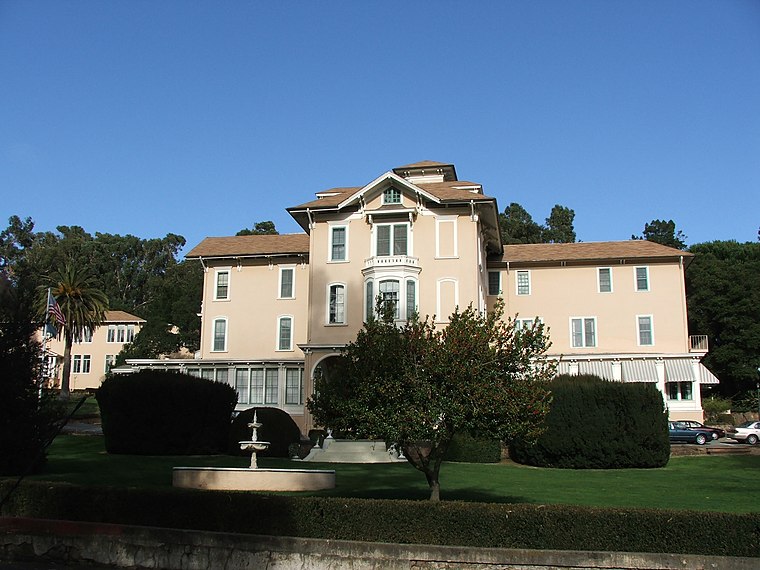
Photo: Kglavin, CC BY-SA 3.0.
Belmont is a city in San Mateo County, California, United States. It is in the San Francisco Bay Area, on the San Francisco Peninsula about halfway between San Francisco and San Jose.
San Carlos

Photo: CityofSanCarlos, CC BY-SA 4.0.
San Carlos is on the Peninsula in the San Francisco Bay Area of California.
Red’s Barn
- Type: Building
- Location: San Mateo, California, United States, North America
- View on OpenStreetMap
Latitude
37.47065° or 37° 28′ 14″ northLongitude
-122.31641° or 122° 18′ 59″ westOpen location code
849VFMCM+7COpenStreetMap ID
way 1027454886OpenStreetMap feature
building=yes
This page is based on OpenStreetMap, Wikidata, and Wikimedia Commons.
We’d love your help improving our open data sources. Thank you for contributing.
Satellite Map
Discover Red’s Barn from above in high-definition satellite imagery.
Notable Places Nearby
Highlights include Redwood Grove and Pool Pavillion.
Nearby Places
Explore places such as Sally MacBride Nature Center and Bluebird Bar.
California: Must-Visit Destinations
Delve into San Francisco, Los Angeles, San Diego, and Sacramento.
Curious Buildings to Discover
Uncover intriguing buildings from every corner of the globe.
About Mapcarta. Data © OpenStreetMap contributors and available under the Open Database License". Text is available under the CC BY-SA 4.0 license, except for photos, directions, and the map. Photo: Wikimedia, CC BY-SA 2.0.