Spokane W.I.N Club
Spokane W.I.N Club is a health club in Spokane, Washington. Spokane W.I.N Club is situated nearby to St. Peter Lutheran Church, as well as near the community center Northeast Youth Center.| Tap on a place to explore it |
Places of Interest Nearby
Highlights include Minnehaha Park and Felts Field.
Minnehaha Park
Park

Photo: Dannooll, CC BY-SA 3.0.
Minnehaha Park is a 39-acre public park located at Euclid Avenue and Havana Street in Spokane, Washington. The land for the park was acquired in 1909 but development did not begin until 1934.
Felts Field
Aerodrome
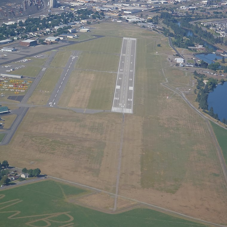
Photo: Gleby, CC BY-SA 3.0.
Felts Field is a public airport in the Northwestern United States, located five miles northeast of Downtown Spokane, in Spokane County, Washington. It is owned by Spokane City-County. Felts Field is situated 2½ miles southeast of Spokane W.I.N Club.
John R Rogers High School
School

Photo: Wikimedia, CC BY-SA 3.0.
John R. Rogers High School is a four-year public secondary school in Bemiss, Spokane, Washington, part of Spokane Public Schools. Opened in 1932 in northeast Spokane, the school is named after John Rankin Rogers, the third governor of the State of Washington. John R Rogers High School is situated 1 mile west of Spokane W.I.N Club.
Places in the Area
Nearby places include Hillyard and Bemiss.
Hillyard
Suburb

Photo: Philsk8thrill, CC BY-SA 3.0.
Hillyard is a neighborhood in Spokane, Washington which existed as a separate town between 1892 and 1924. The town came about due to the Great Northern Railway and was named for James J.
Bemiss
Quarter
Bemiss is a neighborhood in Spokane, Washington. It is located within City Council District 1, which covers the northeastern section of the city. The neighborhood is bounded by Wellesley Avenue to the north, Market Street to the east, Illinois Avenue and the Spokane River to the south, and Perry Street and Napa Street to the west.
Minnehaha
Quarter
Minnehaha is a neighborhood in Spokane, Washington, located in the northeastern portion of the city. The Spokane River flows along the southern edge of the neighborhood, from which the terrain rises along the slopes of Beacon Hill to the northeast.
Spokane W.I.N Club
- Type: Health club
- Categories: building, recreation area, and sports location
- Location: Spokane, Washington, Pacific Northwest, United States, North America
- View on OpenStreetMap
Latitude
47.70162° or 47° 42′ 6″ northLongitude
-117.36504° or 117° 21′ 54″ westOpen location code
85V4PJ2M+JXOpenStreetMap ID
way 1029042565OpenStreetMap feature
building=yesOpenStreetMap feature
leisure=fitness_centre
This page is based on OpenStreetMap, Wikidata, and Wikimedia Commons.
We’d love your help improving our open data sources. Thank you for contributing.
Satellite Map
Discover Spokane W.I.N Club from above in high-definition satellite imagery.
Notable Places Nearby
Highlights include St. Peter Lutheran Church and Northeast Youth Center.
Nearby Places
Explore places such as The Sweat Shop Auto Sales and Cronk Chiropractic.
Washington: Must-Visit Destinations
Delve into Seattle, Olympia, Tacoma, and Spokane.
Curious Health Clubs to Discover
Uncover intriguing health clubs from every corner of the globe.
About Mapcarta. Data © OpenStreetMap contributors and available under the Open Database License". Text is available under the CC BY-SA 4.0 license, except for photos, directions, and the map. Photo: Lumpytrout, CC BY-SA 3.0.