Building MB-4
Building MB-4 is a building in Santa Clara County, California. Building MB-4 is situated nearby to the pitch Hal Daner Field, as well as near the hospital VA Palo Alto Health Care System.| Tap on a place to explore it |
Places of Interest Nearby
Highlights include VA Palo Alto Health Care System and Henry M Gunn High School.
VA Palo Alto Health Care System
Hospital

Photo: Veterans Health, Public domain.
The VA Palo Alto Health Care System is a United States Department of Veterans Affairs healthcare group located in California that consists of three inpatient facilities, plus seven outpatient clinics in San Jose, Capitola, Monterey, Stockton, Modesto, Sonora, and Fremont. VA Palo Alto Health Care System is situated 1,000 feet northwest of Building MB-4.
Henry M Gunn High School
School
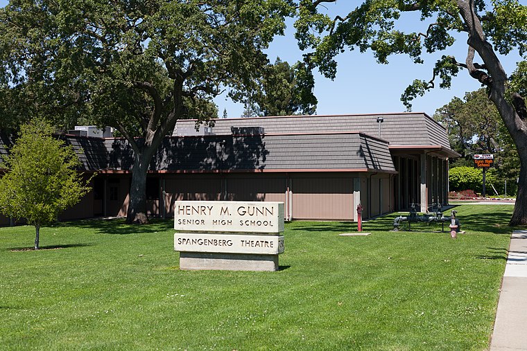
Photo: King of Hearts, CC BY-SA 3.0.
Henry M. Gunn Senior High School is one of two public high schools in Palo Alto, California, the other being Palo Alto High School. Established in 1964, Gunn High School was named after Henry Martin Gunn, who served as the Palo Alto superintendent from 1950 to 1961. Henry M Gunn High School is situated 1,000 feet east of Building MB-4.
Alta Mesa Memorial Park
Cemetery

Photo: Danwri, Public domain.
Alta Mesa Memorial Park is a non-denominational burial ground located in Palo Alto, California, United States. It was established in 1904 as a 72-acre cemetery. It includes traditional burial plots, a mausoleum and a columbarium. Alta Mesa Memorial Park is situated 3,200 feet southeast of Building MB-4.
Places in the Area
Nearby places include College Terrace and Los Altos Hills.
College Terrace
Neighborhood
College Terrace is a neighborhood in the city of Palo Alto, California, adjacent to Stanford University.
Los Altos Hills

Photo: Dicklyon, CC BY-SA 4.0.
Los Altos Hills is a town in Santa Clara County, California. Considered to be one of the "richest" towns in the United States, Los Altos Hills is known for its large homes.
Los Altos

Photo: Coolcaesar, CC BY-SA 3.0.
Los Altos is in Santa Clara County, in the South Bay region of the San Francisco Bay Area in California. The city means "The Heights" or "Foothills" in Spanish.
Building MB-4
- Type: Building
- Location: Santa Clara County, California, United States, North America
- View on OpenStreetMap
Latitude
37.40309° or 37° 24′ 11″ northLongitude
-122.13768° or 122° 8′ 16″ westOpen location code
849VCV36+6WOpenStreetMap ID
way 1036194675OpenStreetMap feature
building=yes
This page is based on OpenStreetMap, Wikidata, and Wikimedia Commons.
We’d love your help improving our open data sources. Thank you for contributing.
Satellite Map
Discover Building MB-4 from above in high-definition satellite imagery.
Notable Places Nearby
Highlights include Hal Daner Field and Barron Park Donkeys.
Nearby Places
Explore places such as Building MB-4 and Building T-6B.
California: Must-Visit Destinations
Delve into San Francisco, Los Angeles, San Diego, and Sacramento.
Curious Buildings to Discover
Uncover intriguing buildings from every corner of the globe.
About Mapcarta. Data © OpenStreetMap contributors and available under the Open Database License". Text is available under the CC BY-SA 4.0 license, except for photos, directions, and the map. Photo: Wikimedia, CC BY-SA 2.0.