PIH Chapel
PIH Chapel is a place of worship in Los Angeles, Southern California, California. PIH Chapel is situated nearby to Presbyterian Intercommunity Hospital, as well as near Children’s Park.| Tap on a place to explore it |
Places of Interest Nearby
Highlights include Presbyterian Intercommunity Hospital and Whittier High School.
Presbyterian Intercommunity Hospital
Hospital

Photo: PIH Health MarCom, CC BY-SA 4.0.
PIH Health Hospital - Whittier is a community hospital in Whittier, California. It has 548 licensed beds as of 2013. Founded in 1959 as Presbyterian Intercommunity Hospital, it has been managed by the nonprofit InterHealth Corporation since the mid-1980s.
Whittier High School
School

Photo: Ormr2014, CC BY-SA 4.0.
Whittier High School is a high school located in Whittier, California. It was the original school of the Whittier Union High School District. It is the alma mater of President Richard Nixon and John Lasseter, founder of Pixar. Whittier High School is situated 1 mile north of PIH Chapel.
Orin Jordan House
House
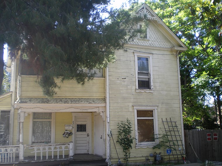
Photo: Los Angeles, CC BY-SA 4.0.
The Orin Jordan House is a Victorian house in Whittier, California that was built in 1888 by Orin Jordan. Also known as the "Old Jordan House" and the "Whitaker Home", the house is located at 8310 S. Orin Jordan House is situated 3,500 feet southeast of PIH Chapel.
Places in the Area
Nearby places include Whittier and West Whittier-Los Nietos.
Whittier
 Whittier is a city of 86,000 in Los Angeles County in Southern California. It was founded by Quakers in 1887 and incorporated in 1898.
West Whittier-Los Nietos
Suburb
West Whittier-Los Nietos is a census-designated place in Los Angeles County, California, United States, near the San Gabriel River and the San Gabriel River Freeway.
Santa Fe Springs

Photo: Downtowngal, CC BY-SA 3.0.
Santa Fe Springs is a city in Los Angeles County, California, United States. It is one of the Gateway Cities of southeast Los Angeles County. The population was 19,219 at the 2020 census, up from 16,223 at the 2010 census.
PIH Chapel
- Type: Place of worship
- Categories: building and religion
- Location: Los Angeles, Southern California, California, United States, North America
- View on OpenStreetMap
Latitude
33.96946° or 33° 58′ 10″ northLongitude
-118.04898° or 118° 2′ 56″ westOpen location code
8553XX92+QCOpenStreetMap ID
way 1044432636OpenStreetMap feature
amenity=place_of_worshipOpenStreetMap feature
building=yes
This page is based on OpenStreetMap, Wikidata, and Wikimedia Commons.
We’d love your help improving our open data sources. Thank you for contributing.
Satellite Map
Discover PIH Chapel from above in high-definition satellite imagery.
Notable Places Nearby
Highlights include Children’s Park and Church of Jesus Christ of Latter Day Saints.
Nearby Places
Explore places such as Wells Medical Office Building and PIH Health Same Day Surgery.
Los Angeles: Must-Visit Destinations
Delve into Hollywood, San Gabriel Valley, San Fernando Valley, and Long Beach.
Curious Place Of Worships to Discover
Uncover intriguing place of worships from every corner of the globe.
About Mapcarta. Data © OpenStreetMap contributors and available under the Open Database License". Text is available under the CC BY-SA 4.0 license, except for photos, directions, and the map. Photo: Mfield, CC BY-SA 3.0.