Villa Puricelli-Plettenberg
Villa Puricelli-Plettenberg is a house in Bretzenheim, Bad Kreuznach, Rhineland-Palatinate which is located on Große Straße. Access is restricted and requires permission. Villa Puricelli-Plettenberg is situated nearby to the historic building Frankensteiner Hof, as well as near the pitch Bolzplatz.| Tap on a place to explore it |
- Access is restricted and requires permission.
- Type: House
- Address: Große Straße 16
Places of Interest Nearby
Highlights include St. Gordianus (Planig) and Auferstehungskirche.
St. Gordianus (Planig)
Church
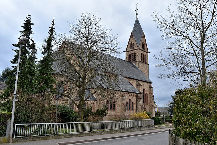
Photo: RomkeHoekstra, CC BY-SA 4.0.
St. Gordianus (Planig) is a church, which is situated 2 km southeast of Villa Puricelli-Plettenberg.
Auferstehungskirche
Church

Photo: RomkeHoekstra, CC BY-SA 4.0.
Auferstehungskirche is a church, which is situated 2 km southeast of Villa Puricelli-Plettenberg.
Eremitage

Photo: Wikimedia, CC BY-SA 2.0 de.
Eremitage is situated 2½ km northwest of Villa Puricelli-Plettenberg.
Places in the Area
Nearby places include Langenlonsheim and Gensingen.
Langenlonsheim
Village

Photo: Wikimedia, Public domain.
Langenlonsheim is an Ortsgemeinde – a municipality belonging to a Verbandsgemeinde, a kind of collective municipality – in the Bad Kreuznach district in Rhineland-Palatinate, Germany.
Gensingen
Gensingen is a village of 400 people in the Naheland. Its evangelical church has an historic stub organ.Biebelsheim
Village

Photo: Wikimedia, Public domain.
Biebelsheim is an Ortsgemeinde – a municipality belonging to a Verbandsgemeinde, a kind of collective municipality – in the Bad Kreuznach district in Rhineland-Palatinate, Germany. Biebelsheim is situated 2½ km east of Villa Puricelli-Plettenberg.
Villa Puricelli-Plettenberg
- Categories: castle, building, historic site, and residential building
- Location: Bretzenheim, Bad Kreuznach, Rhineland-Palatinate, Germany, Central Europe, Europe
- View on OpenStreetMap
Latitude
49.87719° or 49° 52′ 38″ northLongitude
7.90261° or 7° 54′ 9″ eastInception
1750Open location code
8FX9VWG3+V2OpenStreetMap ID
way 1047818897OpenStreetMap feature
building=houseOpenStreetMap feature
historic=castle
This page is based on OpenStreetMap, Wikidata, and Wikimedia Commons.
We’d love your help improving our open data sources. Thank you for contributing.
Satellite Map
Discover Villa Puricelli-Plettenberg from above in high-definition satellite imagery.
Notable Places Nearby
Highlights include Frankensteiner Hof and Bolzplatz.
Nearby Places
Explore places such as Disibodenberger Hof and Grüner Baum.
Rhineland-Palatinate: Must-Visit Destinations
Delve into Mainz, Trier, Koblenz, and Worms.
Curious Houses to Discover
Uncover intriguing houses from every corner of the globe.
About Mapcarta. Data © OpenStreetMap contributors and available under the Open Database License". Text is available under the CC BY-SA 4.0 license, except for photos, directions, and the map. Photo: Traveler100, CC BY-SA 3.0.