Direction Régionale de la Fonction Public
Direction Régionale de la Fonction Public is an office in Manakara Be, Fitovinany which is located on Manakarabe. Direction Régionale de la Fonction Public is situated nearby to the government office Direction Régionale de l’Eau, de l’Assainissement et de l’Hygiène, as well as near the courthouse Tribunal de Première Instance de Manakara.| Tap on a place to explore it |
- Opening hours: Monday—Friday 8:00 AM—5:00 PM
- Type: Office
- Address: Manakarabe, Manakara, 316
Places of Interest Nearby
Highlights include Manakara Airport.
Manakara Airport
Aerodrome
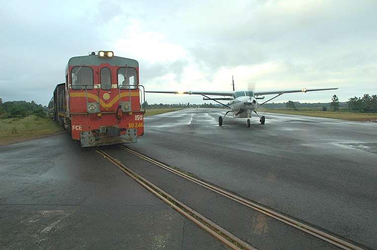
Photo: chirlula, CC BY-SA 2.0.
Manakara Airport is an airport in Manakara, Fitovinany, Madagascar, located on the east coast on the island. The Fianarantsoa-Côte Est railway crosses the runway of this airport, making it is one of only a few airports in the world that crosses a live railway line. Manakara Airport is situated 3 km north of Direction Régionale de la Fonction Public.
Places in the Area
Nearby places include Manakara.
Manakara
Town

Photo: Hardscarf, CC BY-SA 3.0.
Manakara is a city in Madagascar. It is the capital of the Fitovinany Region and of the district of Manakara Atsimo. The city is located at the east coast near the mouth of the Manakara River and has a small port.
Direction Régionale de la Fonction Public
- Category: building
- Location: Manakara Be, Manakara, Manakara-Atsimo, Fitovinany, Madagascar, East African Islands, Africa
- View on OpenStreetMap
Latitude
-22.14558° or 22° 8′ 44″ southLongitude
48.02306° or 48° 1′ 23″ eastOpen location code
5H9CV23F+Q6OpenStreetMap ID
way 1054625126OpenStreetMap feature
building=yesOpenStreetMap feature
office=bureau_administratif
This page is based on OpenStreetMap, Wikidata, and Wikimedia Commons.
We’d love your help improving our open data sources. Thank you for contributing.
Satellite Map
Discover Direction Régionale de la Fonction Public from above in high-definition satellite imagery.
Notable Places Nearby
Highlights include Direction Régionale de l’Eau, de l’Assainissement et de l’Hygiène and Tribunal de Première Instance de Manakara.
Nearby Places
Explore places such as Direction Régionale des Travaux Publics and Banky Foiben’i Madagasikara.
Madagascar: Must-Visit Destinations
Delve into Antananarivo, Toamasina, Antsiranana, and Antsirabe.
Curious Offices to Discover
Uncover intriguing offices from every corner of the globe.
About Mapcarta. Data © OpenStreetMap contributors and available under the Open Database License". Text is available under the CC BY-SA 4.0 license, except for photos, directions, and the map. Photo: Bgag, CC BY-SA 3.0.