Twickenham Food & Wine
Twickenham Food & Wine is a convenience store in Richmond upon Thames, Greater London, England which is located on Whitton Road. Twickenham Food & Wine is situated nearby to the public building All Hallows Church Hall, as well as near the community center Twickenham Training Centre.| Tap on a place to explore it |
Places of Interest Nearby
Highlights include Twickenham Stadium and All Hallows.
Twickenham Stadium
Stadium
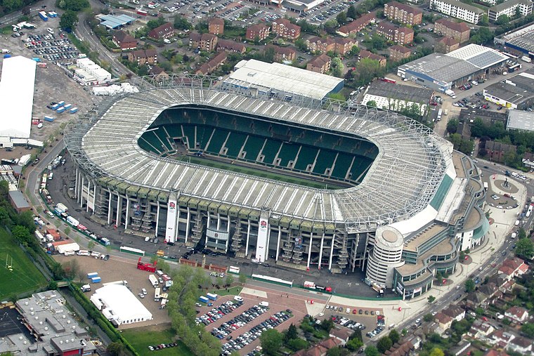
Photo: brewbooks, CC BY-SA 2.0.
Twickenham Stadium is a rugby union stadium in Twickenham, London, England. It is owned by the Rugby Football Union, the English rugby union governing body, which has its headquarters there. Twickenham Stadium is situated 1,500 feet northwest of Twickenham Food & Wine.
All Hallows
Church

Photo: Maxwell Hamilton, CC BY 2.0.
All Hallows Twickenham is a Grade I listed church and parish of the Church of England in Twickenham, London. It incorporates the tower of All Hallows Lombard Street and is prominently south of a major road of west London, near Twickenham Stadium, specifically the Chertsey Road. All Hallows is situated 620 feet northeast of Twickenham Food & Wine.
The Stoop
Stadium

Photo: Cmglee, CC BY-SA 3.0.
Twickenham Stoop Stadium is a stadium located in south-west London, England, situated just across the road from Twickenham Stadium. The stadium is home to the Harlequins in Premiership Rugby and has a capacity of 14,800. The Stoop is situated 2,200 feet southwest of Twickenham Food & Wine.
Places in the Area
Nearby places include Twickenham and St Margarets.
Twickenham
Town
 Twickenham is a suburban district of London, England, on the River Thames 9.9 miles southwest of Charing Cross. Historically in Middlesex, since 1965 it has formed part of the London Borough of Richmond upon Thames, whose administrative headquarters are in the area.
St Margarets
Suburb

Photo: David Kemp, CC BY-SA 2.0.
St Margarets is an affluent suburb and neighbourhood in the London Borough of Richmond upon Thames, about 9 miles west-southwest of central London. It is bounded by the Thames Tideway to the north-east, and the River Crane to the north-west and north where the land tapers between those rivers.
Whitton
Suburb

Photo: David Hawgood, CC BY-SA 2.0.
Whitton is an area of the London Borough of Richmond upon Thames, England. Historically, it was the north-western part of Twickenham manor, bounded by the River Crane and the Duke of Northumberland's River.
Twickenham Food & Wine
- Type: Convenience store
- Address: 103 Whitton Road, Twickenham, TW1 1BZ
- Categories: building, shop, and food
- Location: Richmond upon Thames, Greater London, England, United Kingdom, Britain and Ireland, Europe
- View on OpenStreetMap
Latitude
51.45339° or 51° 27′ 12″ northLongitude
-0.33625° or 0° 20′ 11″ westOpen location code
9C3XFM37+9GOpenStreetMap ID
way 1058386438OpenStreetMap feature
building=yesOpenStreetMap feature
shop=convenience
This page is based on OpenStreetMap, Wikidata, and Wikimedia Commons.
We’d love your help improving our open data sources. Thank you for contributing.
Satellite Map
Discover Twickenham Food & Wine from above in high-definition satellite imagery.
Notable Places Nearby
Highlights include All Hallows Church Hall and Twickenham Training Centre.
Nearby Places
Explore places such as J.D. News & Booze and The Scrummery.
England: Must-Visit Destinations
Delve into London, Manchester, Sheffield, and Leeds.
Curious Convenience Stores to Discover
Uncover intriguing convenience stores from every corner of the globe.
About Mapcarta. Data © OpenStreetMap contributors and available under the Open Database License". Text is available under the CC BY-SA 4.0 license, except for photos, directions, and the map. Photo: sidibousaid, CC BY 2.0.