Ferme Bel Air
Ferme Bel Air is a farm in Estinnes, Arrondissement of Thuin, Wallonia. Ferme Bel Air is situated nearby to Hippisme, as well as near the church Chapelle Saint-Roch.| Tap on a place to explore it |
Places of Interest Nearby
Highlights include Bonne-Espérance Abbey and Basilique Notre-Dame de Bonne-Espérance.
Bonne-Espérance Abbey
College

Photo: Jmh2o, CC BY-SA 4.0.
Bonne-Espérance Abbey was a Premonstratensian abbey that existed from 1130 to the end of the 18th century, located in Vellereille-les-Brayeux in the Walloon municipality of Estinnes, province of Hainaut, Diocese of Tournai, in present-day Belgium. Bonne-Espérance Abbey is situated 1¼ km northwest of Ferme Bel Air.
Basilique Notre-Dame de Bonne-Espérance
Church
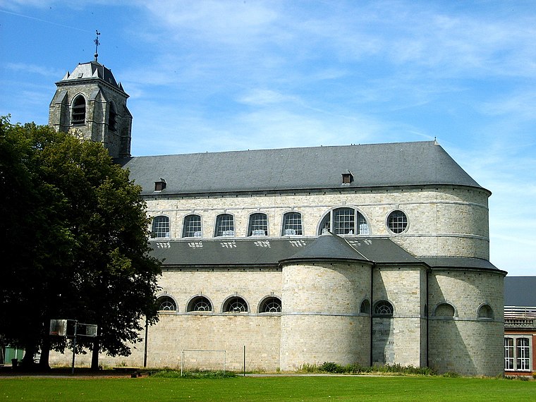
Photo: JNélis, CC BY-SA 3.0.
Basilique Notre-Dame de Bonne-Espérance is a church, which is situated 1¼ km northwest of Ferme Bel Air.
Binche Palace
Castle
Binche Palace was a royal residence located in Binche, in today's Belgian province of Hainaut, Wallonia. The medieval castle and subsequent Renaissance palace served as residence for the counts of Hainaut, the dukes of Burgundy and the Habsburg rulers of the Netherlands. Binche Palace is situated 3½ km north of Ferme Bel Air.
Places in the Area
Nearby places include Binche and Sars-la-Buissière.
Binche

Photo: Jean-Pol GRANDMONT, CC BY 3.0.
Binche is a small town in the Belgian province of Hainaut about 34 miles south of Brussels. The Carnival de Binche Belgium's most famous carnival, attracts thousands of visitors annually.
Sars-la-Buissière
Village

Photo: Jean-Pol GRANDMONT, CC BY 2.0.
Sars-la-Buissière is a village of Wallonia and a district in the municipality of Lobbes, located in the province of Hainaut, Belgium. Sars-la-Buissière is situated 6 km southeast of Ferme Bel Air.
Hantes-Wihéries
Village

Photo: Wikimedia, CC BY-SA 4.0.
Hantes-Wihéries is a village, which is situated 8 km south of Ferme Bel Air.
Ferme Bel Air
- Type: Farm
- Category: agriculture
- Location: Estinnes, Arrondissement of Thuin, Hainaut, Wallonia, Belgium, Benelux, Europe
- View on OpenStreetMap
Latitude
50.37613° or 50° 22′ 34″ northLongitude
4.15314° or 4° 9′ 11″ eastOpen location code
9F2695G3+F7OpenStreetMap ID
way 106304495OpenStreetMap feature
landuse=farmyard
This page is based on OpenStreetMap, Wikidata, and Wikimedia Commons.
We’d love your help improving our open data sources. Thank you for contributing.
Satellite Map
Discover Ferme Bel Air from above in high-definition satellite imagery.
Places with the Same Name
Discover other places named “Ferme Bel Air”.
Notable Places Nearby
Highlights include Hippisme and Chapelle Saint-Roch.
Nearby Places
Explore places such as Vellereille-les-Brayeux Centre and École communale de Vellereille-les-Brayeux.
Hainaut: Must-Visit Destinations
Delve into Charleroi, Mons, Tournai, and La Louvière.
Curious Farms to Discover
Uncover intriguing farms from every corner of the globe.
About Mapcarta. Data © OpenStreetMap contributors and available under the Open Database License". Text is available under the CC BY-SA 4.0 license, except for photos, directions, and the map. Photo: Jean-Pol GRANDMONT, CC BY-SA 3.0.