College Business Park
College Business Park is in Los Angeles, Southern California, California. College Business Park is situated nearby to Granite Creek Community Church, as well as near the sports venue The Claremont Club.| Tap on a place to explore it |
Places of Interest Nearby
Highlights include Cable Airport and Pitzer College.
Cable Airport
Aerodrome
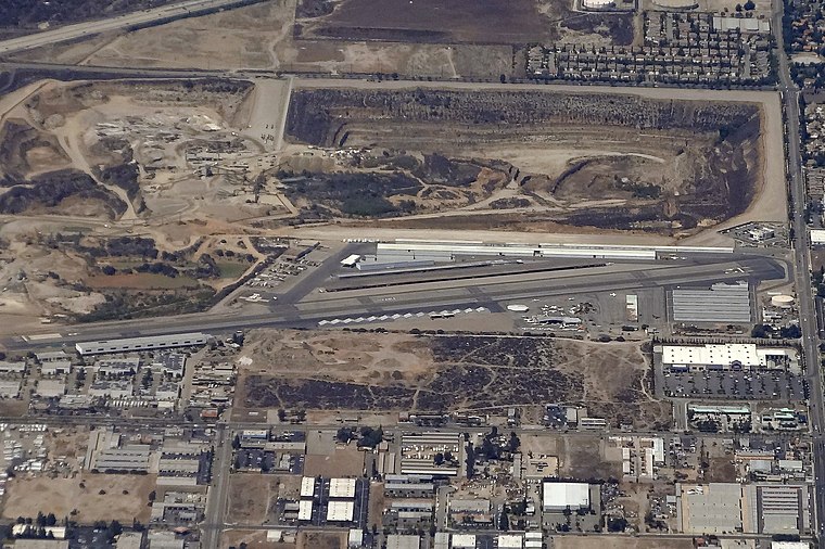
Photo: Eric Salard, CC BY-SA 2.0.
Cable Airport is a non-towered public-use airport located two miles northwest of the central business district of Upland, a city in San Bernardino County, California, United States. It is privately owned by the Cable Land Company.
Pitzer College
University

Photo: Laurielosh, CC BY-SA 4.0.
Pitzer College is a private liberal arts college in Claremont, California. It was founded in 1963 as a women's college in the Claremont Colleges consortium and became coeducational in 1970. Pitzer College is situated 2,900 feet southwest of College Business Park.
Scripps College
University

Photo: Lure Photography, CC BY-SA 3.0.
Scripps College is a private liberal arts women's college in Claremont, California. It was founded as a member of the Claremont Colleges in 1926, a year after the consortium's formation. Scripps College is situated 1 mile southwest of College Business Park.
Places in the Area
Nearby places include Claremont and Montclair.
Claremont

Photo: Nostalgicwisdom, CC BY-SA 3.0.
Claremont is a college town about 30 miles east of Downtown Los Angeles in the eastern San Gabriel Valley of Southern California. It is known for the trees lining its streets and as the home of the elite Claremont Colleges, which together have given it the nickname "City of Trees and PhDs".
Montclair
Town

Photo: Westpacificmovement, CC BY-SA 4.0.
Montclair is a city in the Pomona Valley, in southwestern San Bernardino County, California, 35 miles east of downtown Los Angeles. The population was 37,865 in the 2020 United States census. Montclair is situated 2 miles south of College Business Park.
Upland

Photo: beglib, CC BY-SA 3.0.
Upland is a city in San Bernardino County on the edge of the Inland Empire in Southern California. Formally incorporated in 1906, Upland has a long, rich history in agriculture and included a segment of Route 66.
College Business Park
- Type: Industry
- Location: Los Angeles, Southern California, California, United States, North America
- View on OpenStreetMap
Latitude
34.10946° or 34° 6′ 34″ northLongitude
-117.69723° or 117° 41′ 50″ westOpen location code
85644853+Q4OpenStreetMap ID
way 1080840115OpenStreetMap feature
landuse=industrial
This page is based on OpenStreetMap, Wikidata, and Wikimedia Commons.
We’d love your help improving our open data sources. Thank you for contributing.
Satellite Map
Discover College Business Park from above in high-definition satellite imagery.
Places with the Same Name
Discover other places named “College Business Park”.
Notable Places Nearby
Highlights include Granite Creek Community Church and The Claremont Club.
Nearby Places
Explore places such as JB’s Pool & Pond and J&J Liquor.
Los Angeles: Must-Visit Destinations
Delve into Hollywood, San Gabriel Valley, San Fernando Valley, and Long Beach.
Curious Places to Discover
Uncover intriguing places from every corner of the globe.
About Mapcarta. Data © OpenStreetMap contributors and available under the Open Database License". Text is available under the CC BY-SA 4.0 license, except for photos, directions, and the map. Photo: Mfield, CC BY-SA 3.0.