De Driestroom
De Driestroom is a school in North Brabant, Southern Netherlands which is located on Waalstraat. De Driestroom is situated nearby to the community center Wijkcentrum De Stolp, as well as near the church Radio Maria.| Tap on a place to explore it |
- Type: School
- Description: primary school
- Also known as: “Vrijeschool De Driestroom”
- Address: Waalstraat 30, ‘s-Hertogenbosch, 5215CK
Places of Interest Nearby
Highlights include De Vliert and Burgemeester Lambooijbrug.
De Vliert
Stadium

Photo: LeeGer, CC BY-SA 3.0.
De Vliert is a multi-use stadium in 's-Hertogenbosch, Netherlands. It is currently used mostly for football matches and is the home stadium of FC Den Bosch. De Vliert is situated 1¼ km north of De Driestroom.
Burgemeester Lambooijbrug
Bridge

Photo: Erik Wannee, CC BY-SA 3.0.
Burgemeester Lambooijbrug is a bridge, which is situated 560 metres southwest of De Driestroom.
St. John’s Cathedral
Church
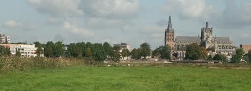
Photo: Klankbeeld, CC BY-SA 4.0.
The Catholic Cathedral Church of St. John of 's-Hertogenbosch, North Brabant, is the height of Gothic architecture in the Netherlands. It has an extensive and richly decorated interior, and serves as the cathedral for the bishopric of 's-Hertogenbosch. St. John’s Cathedral is situated 1½ km west of De Driestroom.
Places in the Area
Nearby places include Zuidoost and Hintham.

Hintham
Neighborhood
Hintham is a village west of Rosmalen in the 's-Hertogenbosch municipality of North Brabant province. Hintham is known for the Interchange Hintham, an interchange in the A2 motorway, the highway from Amsterdam to Maastricht.

De Driestroom
- Categories: primary school and education
- Location: North Brabant, Southern Netherlands, Netherlands, Benelux, Europe
- View on OpenStreetMap
Latitude
51.68994° or 51° 41′ 24″ northLongitude
5.33122° or 5° 19′ 52″ eastOperator
PallasOpen location code
9F37M8QJ+XFOpenStreetMap ID
way 1086690453OpenStreetMap feature
amenity=schoolWikidata ID
Q22754417
This page is based on OpenStreetMap, Wikidata, and Wikimedia Commons.
We’d love your help improving our open data sources. Thank you for contributing.
Satellite Map
Discover De Driestroom from above in high-definition satellite imagery.
In Other Languages
“De Driestroom” goes by many names.
- Dutch: “06XR (BRIN-nummer)”
- Dutch: “Vrije School De Driestroom”
Places with the Same Name
Discover other places named “De Driestroom”.
Notable Places Nearby
Highlights include Wijkcentrum De Stolp and Radio Maria.
Nearby Places
Explore places such as Sanna and Jumbo.
North Brabant: Must-Visit Destinations
Delve into Eindhoven, ’s-Hertogenbosch, Breda, and Tilburg.
Curious Schools to Discover
Uncover intriguing schools from every corner of the globe.
About Mapcarta. Data © OpenStreetMap contributors and available under the Open Database License". Text is available under the CC BY-SA 4.0 license, except for photos, directions, and the map. Photo: WiDi, CC BY-SA 3.0.