All Saints Roman Catholic Junior School
All Saints Roman Catholic Junior School is a school in Liverpool, England. All Saints Roman Catholic Junior School is situated nearby to the public building The Clubmoor, as well as near the recreation area Anfield Sports and Community Centre.| Tap on a place to explore it |
Places of Interest Nearby
Highlights include Anfield and Goodison Park.
Anfield
Stadium

Photo: Arne mueseler, CC BY-SA 3.0 de.
Anfield is a football stadium in the area of Anfield, Liverpool, England, which has been the home of Liverpool F.C. since its formation in 1892. The stadium has a seating capacity of 61,276, making it the fifth-largest football stadium in England. Anfield is situated 3,600 feet west of All Saints Roman Catholic Junior School.
Goodison Park
Stadium
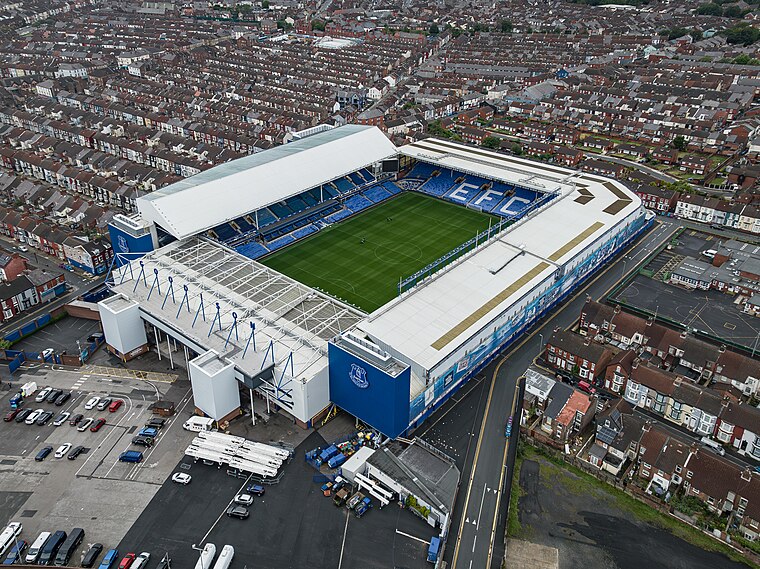
Photo: Arne mueseler, CC BY-SA 3.0 de.
Goodison Park is a football stadium in Walton, Liverpool, England. It is the home of Women’s Super League club Everton, who moved into the ground in 2025. Goodison Park is situated 1 mile northwest of All Saints Roman Catholic Junior School.
Stanley Park
Park
 Stanley Park is a 110 acres park in Liverpool, England, designed by Edward Kemp, which was opened on 14 May 1870 by the Mayor of Liverpool, Joseph Hubback.
Places in the Area
Nearby places include Walton and Everton.
Walton
Suburb

Photo: Rept0n1x, CC BY-SA 3.0.
Walton is an area of Liverpool, in Merseyside, England, north of Anfield and east of Bootle and Orrell Park. Historically in Lancashire, it is largely residential, with a diverse population.
Everton
Suburb

Photo: KGGucwa, CC BY-SA 3.0.
Everton is a suburb of north Liverpool, in Merseyside, England, and part of the Liverpool Walton constituency. It is bordered by Vauxhall to the west, Kirkdale to the north, and Anfield to the north-east.
Vauxhall
Suburb

Photo: Rept0n1x, CC BY-SA 3.0.
Vauxhall is an inner city district of Liverpool, England, north of the city centre, bounded by Kirkdale to the north and Everton to the east, with the docks and River Mersey running along the west side. Vauxhall is situated 2 miles southwest of All Saints Roman Catholic Junior School.
All Saints Roman Catholic Junior School
- Type: School
- Denomination: Roman Catholic
- Category: education
- Location: Liverpool, England, United Kingdom, Britain and Ireland, Europe
- View on OpenStreetMap
Latitude
53.42962° or 53° 25′ 47″ northLongitude
-2.94446° or 2° 56′ 40″ westOpen location code
9C5VC3H4+R6OpenStreetMap ID
way 1119442572OpenStreetMap feature
amenity=schoolOpenStreetMap attribute
denomination=roman_catholic
This page is based on OpenStreetMap, Wikidata, and Wikimedia Commons.
We’d love your help improving our open data sources. Thank you for contributing.
Satellite Map
Discover All Saints Roman Catholic Junior School from above in high-definition satellite imagery.
Notable Places Nearby
Highlights include The Clubmoor and Anfield Sports and Community Centre.
Nearby Places
Explore places such as TOWNSEND LANE/ALL SAINTS RC JUNIOR SCHOOL and TOWNSEND LANE/RECTOR ROAD.
England: Must-Visit Destinations
Delve into London, Manchester, Sheffield, and Leeds.
Curious Schools to Discover
Uncover intriguing schools from every corner of the globe.
About Mapcarta. Data © OpenStreetMap contributors and available under the Open Database License". Text is available under the CC BY-SA 4.0 license, except for photos, directions, and the map. Photo: sidibousaid, CC BY 2.0.