IEM Les chemins de Traverse
IEM Les chemins de Traverse is a building in Noisy-le-Grand, Arrondissement of Le Raincy, Île-de-France which is located on Rue de l’Université. IEM Les chemins de Traverse is situated nearby to the garden Square Constantin Balmont, as well as near the fountain Fontaine du couchant.| Tap on a place to explore it |
- Type: Building
- Address: 23 Rue de l’Université, Noisy-le-Grand, 93160
- Wheelchair access: yes
Places of Interest Nearby
Highlights include Jardin des Sources and Église Saint-Paul-des-Nations.
Jardin des Sources
Park

Photo: Chabe01, CC BY-SA 4.0.
Jardin des Sources is a park, which is situated 220 metres northwest of IEM Les chemins de Traverse.
Église Saint-Paul-des-Nations
Church
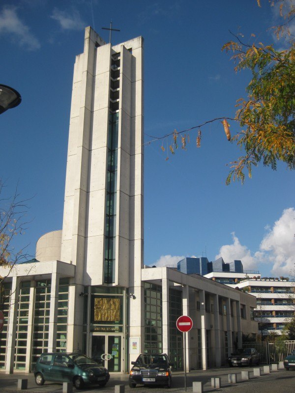 Église Saint-Paul-des-Nations is a church, which is situated 230 metres northwest of IEM Les chemins de Traverse.
Fort de Villiers
Fort

Photo: Wikimedia, Public domain.
Fort de Villers was built following the Franco-Prussian War to defend Paris. Located to the east of Paris in Villiers-sur-Marne, the fort was part of an outer ring of eighteen major fortifications built in response to improvements in the range and effectiveness of artillery since the construction of the Thiers fortifications of the 1840s. Fort de Villiers is situated 430 metres south of IEM Les chemins de Traverse.
Places in the Area
Nearby places include Villiers-sur-Marne and Bry-sur-Marne.
Villiers-sur-Marne
Town

Photo: Hobbes0, CC BY-SA 4.0.
Villiers-sur-Marne is a commune in the eastern suburbs of Paris, France. It is located 14.8 km from the center of Paris. The commune of Villiers-sur-Marne is part of the sector of Porte de Paris, one of the four sectors of the "new town" of Marne-la-Vallée.
Bry-sur-Marne
Town

Photo: Chabe01, CC BY-SA 4.0.
Bry-sur-Marne is a commune in the Val-de-Marne department in the eastern suburbs of Paris, France. It is located 12.6 km from the centre of Paris. Part of the Métropole du Grand Paris, on the departmental border with Seine-Saint-Denis, Bry-sur-Marne is the westernmost commune of Marne-la-Vallée. Bry-sur-Marne is situated 2½ km west of IEM Les chemins de Traverse.
Neuilly-sur-Marne
Town

Photo: Chabe01, CC BY-SA 4.0.
Neuilly-sur-Marne is a French commune in the Seine-Saint-Denis department, Île-de-France. It is located 13.1 km from the center of Paris. Neuilly-sur-Marne is situated 3 km northwest of IEM Les chemins de Traverse.
IEM Les chemins de Traverse
Latitude
48.83731° or 48° 50′ 14″ northLongitude
2.55433° or 2° 33′ 16″ eastOpen location code
8FW4RHP3+WPOpenStreetMap ID
way 111991777OpenStreetMap feature
building=yesOpenStreetMap attribute
wheelchair=yes
This page is based on OpenStreetMap, Wikidata, and Wikimedia Commons.
We’d love your help improving our open data sources. Thank you for contributing.
Satellite Map
Discover IEM Les chemins de Traverse from above in high-definition satellite imagery.
Notable Places Nearby
Highlights include Square Constantin Balmont and Fontaine du couchant.
Nearby Places
Explore places such as École maternelle Jules Verne and Résidence Jacques Brel.
Île-de-France: Must-Visit Destinations
Delve into Paris, Versailles, Boulogne-Billancourt, and Paris Charles de Gaulle Airport.
Curious Buildings to Discover
Uncover intriguing buildings from every corner of the globe.
About Mapcarta. Data © OpenStreetMap contributors and available under the Open Database License". Text is available under the CC BY-SA 4.0 license, except for photos, directions, and the map. Photo: Thibault.taillandier, CC BY-SA 3.0.