Fulham Town Hall
Fulham Town Hall is a municipal building on Fulham Road, Fulham, London. It is a Grade II* listed building.| Tap on a place to explore it |
Photo: Edwardx, CC BY-SA 3.0.
- Type: Event venue
- Description: former town hall in Fulham, London
- Also known as: “Fulham Old Town Hall”
Places of Interest Nearby
Highlights include Stamford Bridge and Fulham Broadway tube station.
Stamford Bridge
Stadium

Photo: Arne mueseler, CC BY-SA 3.0 de.
Stamford Bridge is a football stadium in Fulham, in the Borough of Hammersmith and Fulham, in West London. It is the home of Premier League club Chelsea. Stamford Bridge is situated 1,100 feet northeast of Fulham Town Hall.
Fulham Broadway tube station
Metro station

Photo: Wikimedia, Public domain.
Fulham Broadway is a London Underground station. It is on the Wimbledon branch of the District line, between Parsons Green and West Brompton stations. It is in Travelcard Zone 2. Fulham Broadway tube station is situated 390 feet north of Fulham Town Hall.
Craven Cottage
Stadium
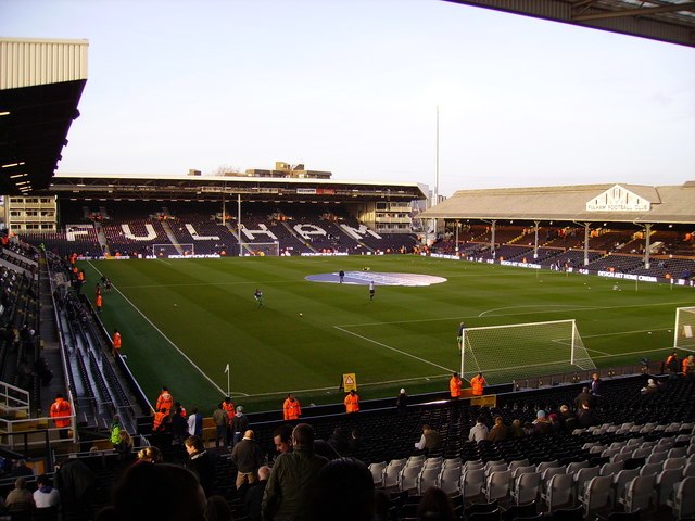
Photo: Kenneth Yarham, CC BY-SA 2.0.
Craven Cottage is a football stadium in Fulham, West London, England, which has been the home of Fulham F.C. since 1896. The ground's capacity is 29,589; the record attendance is 49,335, for a game against Millwall in 1938. Craven Cottage is situated 1¼ miles west of Fulham Town Hall.
Places in the Area
Nearby places include Walham Green and Parsons Green.
Walham Green
Neighborhood
Walham Green is the historic name of an English village, now part of inner London, in the parish of Fulham in the County of Middlesex. It was located between the hamlet of North End to the north, and Parsons Green to the south.
Parsons Green
Neighborhood
 Parsons Green is a mainly residential district in the London Borough of Hammersmith and Fulham. The Green itself, which is roughly triangular, is bounded on two of its three sides by the New King's Road section of the King's Road, A308 road and Parsons Green Lane.
Sands End
Neighborhood

Photo: Derek Harper, CC BY-SA 2.0.
Sands End is an area of the ancient parish of Fulham, formerly in the County of Middlesex, which is now the southernmost part of the London Borough of Hammersmith and Fulham, England.
Fulham Town Hall
- Categories: city hall and building
- Location: Hammersmith and Fulham, Greater London, London, England, United Kingdom, Britain and Ireland, Europe
- View on OpenStreetMap
Latitude
51.47984° or 51° 28′ 47″ northLongitude
-0.19472° or 0° 11′ 41″ westOpen location code
9C3XFRH4+W4OpenStreetMap ID
way 113430586OpenStreetMap feature
amenity=events_venueOpenStreetMap feature
building=yesWikidata ID
Q15221190
This page is based on OpenStreetMap, Wikidata, Wikimedia Commons, and Wikipedia.
We’d love your help improving our open data sources. Thank you for contributing.
Satellite Map
Discover Fulham Town Hall from above in high-definition satellite imagery.
In Other Languages
From French to Spanish—“Fulham Town Hall” goes by many names.
- French: “Fulham Town Hall”
- Polish: “Ratusz w Fulham”
- Spanish: “Ayuntamiento de Fulham”
Notable Places Nearby
Highlights include Fulham Broadway Methodist Church and BIMM Institute London.
Nearby Places
Explore places such as Fulham Broadway Station and Wendy’s.
London: Must-Visit Destinations
Delve into South Kensington-Chelsea, Heathrow Airport, City of London, and Westminster.
Curious Event Venues to Discover
Uncover intriguing event venues from every corner of the globe.
About Mapcarta. Data © OpenStreetMap contributors and available under the Open Database License". Text is available under the CC BY-SA 4.0 license, except for photos, directions, and the map. Description text is based on the Wikipedia page “Fulham Town Hall”. Photo: Edwardx, CC BY-SA 3.0.