Le Bois des Roussières
Le Bois des Roussières is a forest in Guyancourt, Arrondissement of Versailles, Île-de-France. Le Bois des Roussières is situated nearby to the locality La Culotte, as well as near Clos de la Ferme de Châteauneuf.| Tap on a place to explore it |
Places of Interest
Highlights include Vélodrome National and Saint-Quentin-en-Yvelines–Montigny-le-Bretonneux station.
Vélodrome National
Stadium

Photo: Lionel Allorge, CC BY-SA 3.0.
The Vélodrome National de Saint-Quentin-en-Yvelines is a velodrome in Montigny-le-Bretonneux, France. It was built between 2011 and 2014 and hosted the 2015, 2022 UCI Track Cycling World Championships, and the 2016 UEC European Track Championships.
Saint-Quentin-en-Yvelines–Montigny-le-Bretonneux station
Railway station

Photo: Henrysalome, CC BY-SA 3.0.
Saint-Quentin-en-Yvelines–Montigny-le-Bretonneux is a station on the Paris–Brest railway. It is served by Paris's express suburban rail system, the RER Line C and by suburban Transilien Line N and U services.
Fort de Saint-Cyr
Fort
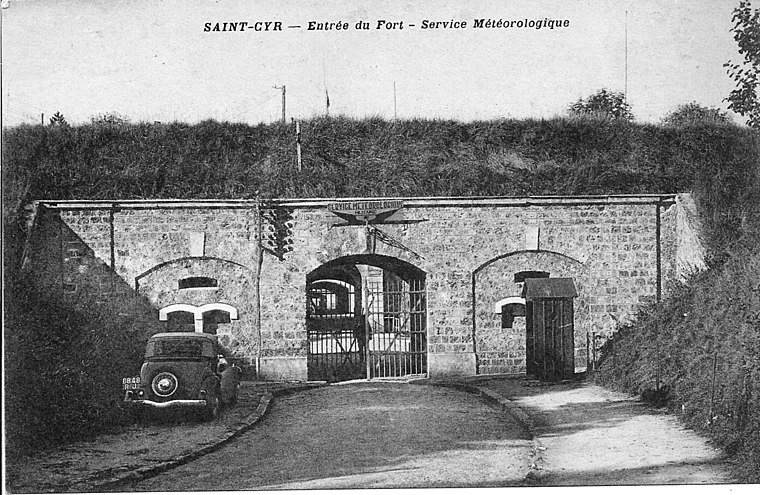
Photo: Langladure, CC BY-SA 3.0.
The Fort de Saint-Cyr, located in the commune of Montigny-le-Bretonneux, is one of the forts built at the end of the 19th century to defend Paris. After the first world war the fort was used as an army weather station and arms depot.
Places in the Area
Nearby places include Saint-Quentin-en-Yvelines and Versailles.
Saint-Quentin-en-Yvelines

Photo: Lionel Allorge, CC BY-SA 3.0.
Saint-Quentin-en-Yvelines, often abbreviated to SQY, is a conurbation of several new towns South-West of Paris. Tourists are most likely to come here to visit France Miniature, for outdoor sports and as a gateway to the Haute Vallée de Chevreuse National…
Versailles
 Versailles is a city on the western edge of the French capital city Paris, now part of the sprawling metropolis within the Ile de France region. Versailles is best known for being the site of the vast royal palace and gardens built by King Louis XIV on what had been the grounds of a royal hunting lodge.
Montigny-le-Bretonneux
Town

Photo: Wikimedia, CC BY-SA 3.0.
Montigny-le-Bretonneux is a commune in the Yvelines department in the Île-de-France region in north-central France. It is located in the south-western suburbs of Paris, 24.5 kilometres from the centre of Paris, in the "new town" of Saint-Quentin-en-Yvelines, of which it is the central and most populated commune.
Le Bois des Roussières
- Type: Forest
- Location: Guyancourt, Arrondissement of Versailles, Yvelines, Île-de-France, France, Europe
- View on OpenStreetMap
Latitude
48.7798° or 48° 46′ 47″ northLongitude
2.0548° or 2° 3′ 17″ eastOpen location code
8FW4Q3H3+WWOpenStreetMap ID
way 113972705OpenStreetMap feature
landuse=forest
This page is based on OpenStreetMap, Wikidata, and Wikimedia Commons.
We’d love your help improving our open data sources. Thank you for contributing.
Satellite Map
Discover Le Bois des Roussières from above in high-definition satellite imagery.
Localities in the Area
Explore places such as La Culotte and Clos de la Ferme de Châteauneuf.
Notable Places Nearby
Highlights include Étang des Roussières and Ehpad Les Saules.
Île-de-France: Must-Visit Destinations
Delve into Paris, Versailles, Boulogne-Billancourt, and Paris Charles de Gaulle Airport.
Curious Forests to Discover
Uncover intriguing forests from every corner of the globe.
About Mapcarta. Data © OpenStreetMap contributors and available under the Open Database License". Text is available under the CC BY-SA 4.0 license, except for photos, directions, and the map. Photo: Inkey, CC BY-SA 3.0.