Bideford (Strand) Bowling Club
Bideford (Strand) Bowling Club is a building in Bideford, Torridge District, England. Bideford (Strand) Bowling Club is situated nearby to the art gallery Strand Gallery, as well as near the church North Road Chapel.| Tap on a place to explore it |
Places of Interest Nearby
Highlights include Burton at Bideford and Victoria Park.
Burton at Bideford
Museum
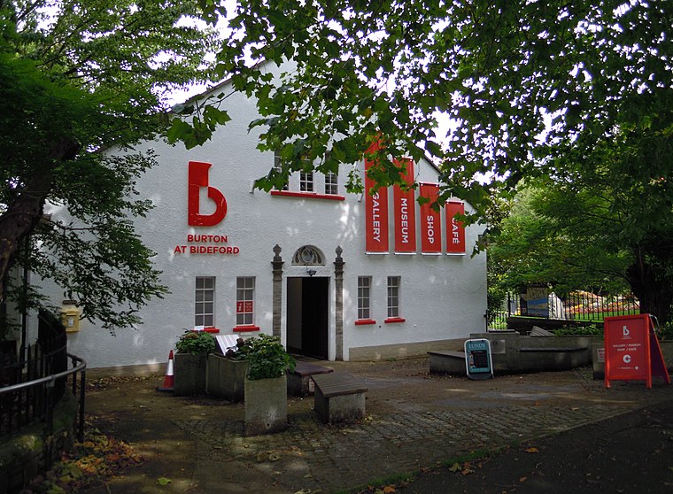 The Burton at Bideford is an art gallery and museum on Kingsley Road in Victoria Park, in Bideford, Devon, England. It houses collections on various topics connected with Bideford’s history and cultural heritage. Burton at Bideford is situated 590 feet east of Bideford (Strand) Bowling Club.
Victoria Park
Park
Victoria Park is an urban park in Bideford, Devon, England. The park opened in 1912 to celebrate the reign of Queen Victoria, the gates erected for the opening are listed with Historic England. Victoria Park is situated 880 feet northeast of Bideford (Strand) Bowling Club.
Pannier Market
Marketplace

Photo: Jack1956, CC BY-SA 4.0.
The Pannier Market in Bideford in North Devon is a large covered Victorian pannier market together with the Butcher's Row of small artisan stalls running along the lower level of the Market. Pannier Market is situated 1,500 feet south of Bideford (Strand) Bowling Club.
Places in the Area
Nearby places include Westward Ho! and Appledore.
Westward Ho!
 Westward Ho! is a quaintly-named seaside town in Torridge, Devon, England, near Bideford! Beware however, that's where the quaintness ends. Westward Ho! is in some need of investment, although it retains a good variety of quality local businesses, and its beach is highly regarded and noted for the cleanliness of its water.
Appledore
Village
Photo: Sannse, CC BY-SA 3.0.
Appledore is a village at the mouth of the River Torridge, about 6 miles west of Barnstaple and about 3 miles north of Bideford in the county of Devon, England. Appledore is situated 2½ miles north of Bideford (Strand) Bowling Club.
Horwood
Hamlet

Photo: Jonathan Billinger, CC BY-SA 2.0.
Horwood is a village and former civil parish, now in the parish of Horwood, Lovacott and Newton Tracey, in the North Devon district, in the county of Devon, England, situated about 4 miles east of the town of Bideford. Horwood is situated 3 miles east of Bideford (Strand) Bowling Club.
Bideford (Strand) Bowling Club
- Type: Building
- Roof shape: gabled
- Location: Bideford, Torridge District, North Devon, Devon, West Country, England, United Kingdom, Britain and Ireland, Europe
- View on OpenStreetMap
Latitude
51.02101° or 51° 1′ 16″ northLongitude
-4.20768° or 4° 12′ 28″ westLevels
1Open location code
9C3Q2QCR+CWOpenStreetMap ID
way 1178698910OpenStreetMap feature
building=yesOpenStreetMap attribute
roof-shape=gabled
This page is based on OpenStreetMap, Wikidata, and Wikimedia Commons.
We’d love your help improving our open data sources. Thank you for contributing.
Satellite Map
Discover Bideford (Strand) Bowling Club from above in high-definition satellite imagery.
Notable Places Nearby
Highlights include Strand Gallery and North Road Chapel.
Nearby Places
Explore places such as Texaco and Bideford Tool Ltd.
North Devon: Must-Visit Destinations
Delve into Barnstaple, Lundy, Ilfracombe, and Exmoor National Park.
Curious Buildings to Discover
Uncover intriguing buildings from every corner of the globe.
About Mapcarta. Data © OpenStreetMap contributors and available under the Open Database License". Text is available under the CC BY-SA 4.0 license, except for photos, directions, and the map. Photo: RobThinks, CC BY-SA 4.0.