HS2
HS2 is in Coleshill, North Warwickshire District, England. HS2 is situated nearby to the forest The Belt, as well as near the manor estate Coleshill Manor Office Campus.| Tap on a place to explore it |
Places of Interest Nearby
Highlights include Church of St Peter and St Paul, Coleshill and Coleshill Parkway railway station.
Church of St Peter and St Paul, Coleshill
Church
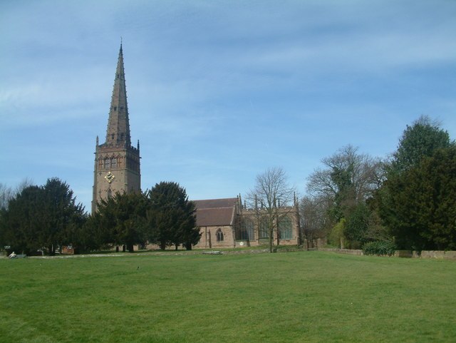
Photo: Mark Walton, CC BY-SA 2.0.
The Church of St. Peter and St. Paul, often referred to as Coleshill Parish Church, is the Anglican parish church of Coleshill, Warwickshire, England. It has been a Grade I listed building since 1961, and was built between the 14th and 15th centuries, with the current spire built in the 1860s. Church of St Peter and St Paul, Coleshill is situated 3,900 feet southeast of HS2.
Coleshill Parkway railway station
Railway station

Photo: David Stowell, CC BY-SA 2.0.
Coleshill Parkway is a railway station at Hams Hall on the Birmingham to Peterborough railway line, serving Coleshill in Warwickshire, England. Sitting on the site of the former Coleshill station which closed in 1968, the current station was opened in 2007. Coleshill Parkway railway station is situated 1 mile northeast of HS2.
Blyth Hall
Building

Photo: David Stowell, CC BY-SA 2.0.
Blyth Hall is a privately owned mansion house on the banks of the River Blythe situated near Shustoke, Warwickshire. It is a Grade I listed building. The estate was purchased in 1625 by Sir William Dugdale, a prominent antiquarian, who shortly thereafter built a new house on the site. Blyth Hall is situated 1¼ miles east of HS2.
Places in the Area
Nearby places include Gilson and Coleshill.
Gilson
Hamlet
Gilson is a hamlet in the civil parish of Coleshill, in the North Warwickshire district of Warwickshire, England. It lies between the M42 and the A446, on the B4117 road between the village of Water Orton and the small market town of Coleshill.
Coleshill
Town

Photo: John A Lainchbury, CC BY-SA 2.0.
Coleshill is a market town and civil parish in the North Warwickshire district of Warwickshire, England, taking its name from the River Cole, on which it stands.
Water Orton
Village

Photo: Paul, CC BY-SA 2.0.
Water Orton is a village and civil parish in the North Warwickshire borough of Warwickshire in the West Midlands, England near the River Tame. It is located between Castle Bromwich and Coleshill, and borders the West Midlands metropolitan county boundary to the north, west and south.
HS2
Latitude
52.50357° or 52° 30′ 13″ northLongitude
-1.72079° or 1° 43′ 15″ westOpen location code
9C4WG73H+CMOpenStreetMap ID
way 1181073920OpenStreetMap feature
landuse=construction
This page is based on OpenStreetMap, Wikidata, and Wikimedia Commons.
We’d love your help improving our open data sources. Thank you for contributing.
Satellite Map
Discover HS2 from above in high-definition satellite imagery.
Places with the Same Name
Discover other places named “HS2”.
Notable Places Nearby
Highlights include The Belt and Coleshill Manor Office Campus.
Nearby Places
Explore places such as HS2 and HS2.
Warwickshire: Must-Visit Destinations
Delve into Stratford-upon-Avon, Warwick, Rugby, and Leamington Spa.
Curious Places to Discover
Uncover intriguing places from every corner of the globe.
About Mapcarta. Data © OpenStreetMap contributors and available under the Open Database License". Text is available under the CC BY-SA 4.0 license, except for photos, directions, and the map. Photo: brianac37, CC BY 2.0.