2. Trolejbusu Parks
2. Trolejbusu Parks is in Riga, Riga region. 2. Trolejbusu Parks is situated nearby to the suburb Torņakalns, as well as near the sauna Pārdaugavas malkas pirts.| Tap on a place to explore it |
Places of Interest Nearby
Highlights include National Library of Latvia and Torņakalns Station.
National Library of Latvia
Library

Photo: Yeti-Hunter, CC BY-SA 4.0.
The National Library of Latvia, originally known as the State Library of Latvia, is a national cultural institution under the supervision of the Ministry of Culture of Latvia. National Library of Latvia is situated 1 km north of 2. Trolejbusu Parks.
Torņakalns Station
Railway station
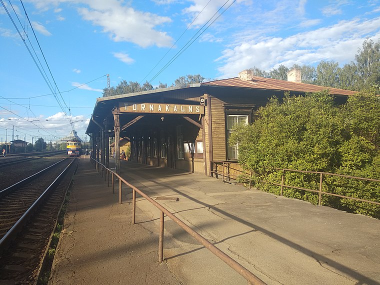 Torņakalns Station is a railway station in the neighbourhood of Torņakalns in the Zemgale Suburb in Riga, Latvia, located on the western bank of the Daugava River. Torņakalns Station is situated 440 metres west of 2. Trolejbusu Parks.
House of the Black Heads

Photo: Diliff, CC BY-SA 3.0.
The House of the Blackheads is a building situated in the old town of Riga, Latvia. The original building was erected in 1334 as a warehouse, meeting and celebration place for merchants. House of the Black Heads is situated 2 km north of 2. Trolejbusu Parks.
Places in the Area
Nearby places include Torņakalns and Pārdaugava.
Torņakalns
Suburb

Photo: Smig, CC BY-SA 3.0.
Torņakalns is a neighbourhood of Riga, Latvia located on the western bank of the Daugava River. The name Torņakalns derives from a fortified tower built in the Middle Ages close to the Daugava River to alert the city of Riga in case of emergency and intruders about to cross the river.
Pārdaugava

Photo: Guillaume Speurt, CC BY-SA 2.0.
Pārdaugava, which literally means "over Daugava" or "across the Daugava", is a part of Riga, comprising the west bank of Daugava river.
Agenkalne Inlet
Suburb

Photo: Misters32, CC BY-SA 4.0.
Āgenskalns is a district in Riga, located on the left bank of the Daugava, an old neighbourhood, mainly built in the late 19th to early 20th century. The total area of Āgenskalns is 4,6 km2, which is a lot less than other districts of Riga.
2. Trolejbusu Parks
- Type: Industry
- Location: Riga, Riga region, Latvia, Baltic states, Europe
- View on OpenStreetMap
Latitude
56.93189° or 56° 55′ 55″ northLongitude
24.0962° or 24° 5′ 46″ eastOpen location code
9G86W3JW+QFOpenStreetMap ID
way 119816334OpenStreetMap feature
landuse=industrial
This page is based on OpenStreetMap, Wikidata, and Wikimedia Commons.
We’d love your help improving our open data sources. Thank you for contributing.
Satellite Map
Discover 2. Trolejbusu Parks from above in high-definition satellite imagery.
Notable Places Nearby
Highlights include Pārdaugavas malkas pirts and Latvijas Universitātes akadēmiskais centrs.
Nearby Places
Explore places such as Ēdnīca ‘Busiņš’ and 2. trolejbusu parks.
Riga: Must-Visit Destinations
Delve into Vecrīga, Centrs, Outer East Bank, and Pārdaugava.
Curious Places to Discover
Uncover intriguing places from every corner of the globe.
About Mapcarta. Data © OpenStreetMap contributors and available under the Open Database License". Text is available under the CC BY-SA 4.0 license, except for photos, directions, and the map. Photo: Poco a poco, CC BY-SA 3.0.